Apuan Alps
| Apuan Alps | |
|---|---|
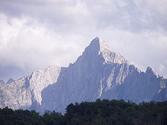
 Apuan Alps seen from Pietrasanta. | |
| Highest point | |
| Peak | Monte Pisanino |
| Elevation | 1,946 m (6,385 ft) |
| Coordinates | 44°08′01″N 10°12′52″E / 44.13361°N 10.21444°E |
| Geography | |
| Country | Italy |
| Region | Tuscany |
| Parent range | Apennine Mountains |
| Geology | |
| Age of rock | Triassic |

The Apuan Alps (Italian: Alpi Apuane) are a mountain range in northern Tuscany, Italy. They are included between the valleys of the Serchio and Magra rivers, and, to north-west, the Garfagnana and Lunigiana, with a total length of approximately 55 kilometres (34 mi).[1] The name derives from the Apuani Ligures tribe who lived here in ancient times.
Geology and geography
The chain formed out of sea sediments in the middle Triassic period, somewhat earlier than the rest of the Apennines, and on a rather different geological structure.[1] Over time, these sediments hardened into limestone, dolomite, sandstone, and shale.[1] Harsh pressure approximately 25 million years ago transformed the limestone in many places into the Carrara marble (named for the nearby city of Carrara) for which the range is renowned.[1] Erosion carved much of the remaining sedimentary rocks into a jagged karst topography.
The highest peak is the Monte Pisanino, at 1,946 metres (6,385 ft).[1]
Main peaks
- Monte Pisanino (1,946 m)
- Monte Tambura (1,890 m)
- Monte Cavallo (1,888 m)
- Pania della Croce (1,858 m)
- Monte Grondìlice (1,808 m)
- Monte Contrario (1,788 m)
- Pizzo d'Uccello (1,781 m)
- Monte Sumbra (1765 m)
- Monte Sagro (1,749 m)
References
External links
![]() Media related to Apuan Alps at Wikimedia Commons
Media related to Apuan Alps at Wikimedia Commons

