
Arrecife
Arrecife | |
|---|---|
City | |
 Flag  Coat of arms | |
| Country | |
| Autonomous Community | |
| Province | Las Palmas |
| Island | Lanzarote |
| Government | |
| • Mayor | Manuel Fajardo Feo (CC) |
| Area | |
| • Total | 23 km2 (9 sq mi) |
| Elevation (AMSL) | 20 m (70 ft) |
| Population (2012) | |
| • Total | 56,284 |
| • Density | 2,400/km2 (6,300/sq mi) |
| Time zone | UTC+0 (CET) |
| • Summer (DST) | UTC+1 (CEST (GMT +1)) |
| Postal code | 35500 |
| Area code | +34 (Spain) + 928 (Las Palmas) |
| Website | www.arrecife.es |
Arrecife (/ˌærəˈsiːfeɪ/; Spanish pronunciation: [areˈθife], locally [areˈsife]) is a city and municipality in the Canary Islands (Spain) situated in the centre-east of the island of Lanzarote, of which it has been the capital since 1852. The city owes its name to the rock reef ('Arrecife' is Spanish for 'reef') which covers the beach located in the city. The city also gives its name to the island's nearby airport.
The population is 56,284 (2012), its density is 2,235.25/km² and the area is 22.72 km². It is south of Haría, east of Tinajo and northeast of Yaiza. Arrecife is also a port town serving the other islands and also Europe and mainland Africa. Arrecife is served by the LZ1 linking it to the north, LZ2 and LZ3 and is bypassed to the northwest and west. The highway to the southern portion of the island lies to the west. The main industries are agriculture, business and tourism. The Atlantic Ocean is to the east and southeast, the mountains are to the north, the hills lie to the west and farmlands dominate the rest of the municipality. The tallest building in Lanzarote is the Gran Hotel Arrecife, which is located on the front alongside the harbour.
History
The earliest records of Arrecife date from the fifteenth century when it was a small fishing settlement. The name, given then as Arrecifes, refers to the black volcanic reefs behind which boats could hide, protected from sudden pirate attacks.
Towards the end of the sixteenth century the settlement began to grow in response to a need for accommodation and warehousing to support growing trade between the old and new worlds. The first church was constructed at this time, consecrated to the first bishop of Arrecife, San Ginés. Growing prosperity increased the attractiveness of the town as a pirate target: in 1571 a notorious pirate named Dogan plundered and almost completely destroyed the little port town.
In 1964 Arrecife became the site of Lanzarote's first sea-water desalination plant, which was still operational in 2010.
Historical population
| Year | Population | Change |
|---|---|---|
| 2001 | 45,549 | - |
| 2002 | 48,253 | 2,704/5.94% |
| 2003 | 50,785 | 2,532/5.25% |
Communities
- Urbanización Playa Honda (subdivision), south.
Sites of interest
- Playa Reducto, Arrecife's town beach.
- Castillo de San Jose, 17th-century fortification that now houses a collection of modern art.
- Puente de Las Bolas, Bridge leading to the Castillo de San Gabriel.
- Charco de San Ginés, A man-made lagoon used by fishermen.
Other
Arrecife has schools, lyceums, a gymnasia, a church, beaches, a port, a post office, parks and a square (plaza), cinemas as well as a few small shopping malls and a shopping-area main street.
Gallery
-
 Church
 -
 The Gran Hotel Arrecife
 -
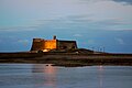 Castle of San Gabriel


See also
External links
| North: Teguise | ||
| West: San Bartolomé |
Arrecife | East: Atlantic Ocean |
| South: Atlantic Ocean |