Arzúa
Appearance
Concello de Arzúa | |
|---|---|
municipality | |
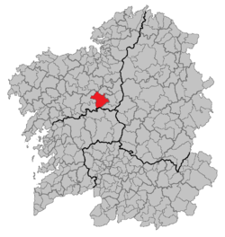
 Location of Arzúa within Galicia | |
| Parroquias | Santa María de Arzúa, Santiago de Arzúa, Boente, Brandeso, Branzá, Burres, Calvos de Sobrecamiño, O Campo, Castañeda, Dodro, Dombodán, Figueiroa, Lema, Maroxo, A Mella, Oíns, Pantiñobre, Rendal, Tronceda, Viladavil, Vilantime & Viñós |
| Area | |
| • Total | 155.89 km2 (60.19 sq mi) |
| Population (2012) | |
| • Total | 6,315 (INE) |
| • Density | 40.64/km2 (105.3/sq mi) |
| Time zone | UTC+1 (CET) |
| • Summer (DST) | UTC+2 (CET) |
| Website | Concello de Arzúa |
Arzúa (Spanish pronunciation: [arˈθu.a]) is a municipality in the autonomous community of Galicia in the province of A Coruña in northwestern Spain. It has an area of 155.89 km², a population of 6,315 (2012 estimate), and a population density of 40.64 people/km². It is one of the Galician municipalities with more cows per capita rate in Galicia.
Demographics
| Year | Pop. | ±% |
|---|---|---|
| 1900 | 9,036 | — |
| 1930 | 8,743 | −3.2% |
| 1950 | 10,754 | +23.0% |
| 1981 | 7,377 | −31.4% |
| 2012 | 6,315 | −14.4% |
| Source: Article in Spanish and Galician | ||

