
Aurec-sur-Loire
Aurec-sur-Loire | |
|---|---|
 A general view of Aurec-sur-Loire | |
 Coat of arms | |
Location of Aurec-sur-Loire  | |
| Country | France |
| Region | Auvergne-Rhône-Alpes |
| Department | Haute-Loire |
| Arrondissement | Yssingeaux |
| Canton | Aurec-sur-Loire |
| Intercommunality | Loire-Semène |
| Government | |
| • Mayor (2008–2014) | Claude Vial |
| Area 1 | 22.44 km2 (8.66 sq mi) |
| Population (2009) | 5,557 |
| • Density | 250/km2 (640/sq mi) |
| Time zone | UTC+01:00 (CET) |
| • Summer (DST) | UTC+02:00 (CEST) |
| INSEE/Postal code | 43012 /43110 |
| Elevation | 414–821 m (1,358–2,694 ft) (avg. 432 m or 1,417 ft) |
| 1 French Land Register data, which excludes lakes, ponds, glaciers > 1 km2 (0.386 sq mi or 247 acres) and river estuaries. | |
Aurec-sur-Loire is a commune in the Haute-Loire department in south-central France.
Population
| Year | Pop. | ±% |
|---|---|---|
| 1936 | 2,668 | — |
| 1954 | 2,745 | +2.9% |
| 1962 | 3,106 | +13.2% |
| 1968 | 3,620 | +16.5% |
| 1975 | 3,975 | +9.8% |
| 1982 | 4,248 | +6.9% |
| 1990 | 4,510 | +6.2% |
| 1999 | 4,895 | +8.5% |
| 2009 | 5,557 | +13.5% |
Galleries
-
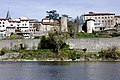 Ramparts.
 -
 Former doorway to the Castle.
 -
 North face
 -
 Tower of the Burgundians.
 -
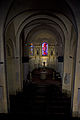 Nave.
Nave. -
 Baptismal Fonts
 -
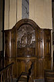
 Altar and altarpiece.
 -
 Pieta.
 -
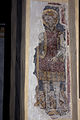
 St. Peter.
 -
 St. Michael.


.jpg)


See also
References
Wikimedia Commons has media related to Aurec-sur-Loire.
This Haute-Loire geographical article is a stub. You can help Wikipedia by expanding it. |