
Austinville, Virginia
Austinville, Virginia | |
|---|---|
 | |
| Coordinates: 36°51′04″N 80°54′43″W / 36.8512342°N 80.9120233°W[1] | |
| Country | United States |
| State | Virginia |
| County | Wythe |
| Elevation | 2,130 ft (650 m) |
| ZIP code | 24312 |
| Area code | 276 |
Austinville is an unincorporated community on the New River in southern Wythe County, Virginia, United States. New River Trail State Park runs through Austinville, and Shot Tower Historical State Park is located nearby. The town is the birthplace of Stephen F. Austin, for whose family it is named.
The ZIP code (mail delivery region) for Austinville extends south into neighboring Carroll County.
Austinville is built on the location of Lead Mines, Virginia, the seat of the former Fincastle County.
References
Municipalities and communities of Wythe County, Virginia, United States | ||
|---|---|---|
| Towns | 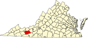 | |
| CDPs | ||
| Other communities | ||
This Wythe County, Virginia state location article is a stub. You can help Wikipedia by expanding it. |