Bagoué
Bagoué Region
Région de la Bagoué | |
|---|---|
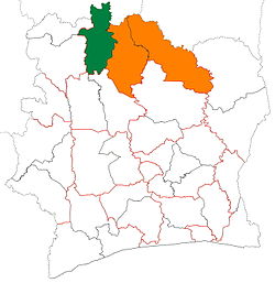
 Location of Bagoué Region (green) in Ivory Coast and in Savanes District | |
| Country | |
| District | Savanes |
| Established | 2011 |
| Regional seat | Boundiali |
| Government | |
| • Prefect | Issa Coulibaly |
| • Council President | Siama Bamba |
| Area | |
| • Total | 10,668 km2 (4,119 sq mi) |
| Population (2014)[4] | |
| • Total | 375,687 |
| • Density | 35/km2 (91/sq mi) |
| Time zone | UTC+0 (GMT) |
Bagoué Region is one of the 31 regions of Ivory Coast. Since its establishment in 2011, it has been one of three regions in Savanes District. The seat of the region is Boundiali and the region's population in the 2014 census was 375,687.
Bagoué is divided into three departments: Boundiali, Kouto, and Tengréla.
Notes
- ^ "Préfets de Région et de Préfets de Département (Conseil des ministres du mercredi 26 septembre 2012)", abidjan.net, 2 October 2012.
- ^ "Région de la Bagoué: le Conseil Régional investit plus de 48 millions dans les cantines scolaires", abidjan.net, 26 February 2016.
- ^ "Bagoué", gouv.ci, accessed 23 February 2016.
- ^ "Côte d'Ivoire". geohive.com. Retrieved 5 December 2015.
9°31′N 6°29′W / 9.517°N 6.483°W


