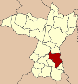
Ban Phai district
Ban Phai
บ้านไผ่ | |
|---|---|
 Amphoe location in Khon Kaen Province | |
| Coordinates: 16°3′36″N 102°43′51″E / 16.06000°N 102.73083°E | |
| Country | |
| Province | Khon Kaen |
| Area | |
| • Total | 477.7 km2 (184.4 sq mi) |
| Population (2007) | |
| • Total | 101,031 |
| • Density | 211.5/km2 (548/sq mi) |
| Time zone | UTC+7 (THA) |
| Postal code | 40110 |
| Geocode | 4010 |
Ban Phai (Thai: บ้านไผ่, pronounced [bâːn pʰàj]) is a district (Amphoe) of Khon Kaen Province, northeastern Thailand.
Geography
Neighboring districts are (from the south clockwise) Pueai Noi, Nong Song Hong, Non Sila, Chonnabot, Mancha Khiri and Ban Haet of Khon Kaen Province, Kosum Phisai and Kut Rang of Maha Sarakham Province.
History
Originally named Ban Keng (บ้านเกิ้ง), the area was at first a subdistrict (tambon) of Chonnabot district. In 1928 the minor district (King Amphoe) Ban Phai was established consisting of three subdistricts split off from Chonnabot,[1] which was upgraded to a full district on February 1, 1940.[2] 1946 Chonnabot was downgraded to be a part of Ban Phai district, until it was reestablished in 1966.
Administration
The district is subdivided into 10 subdistricts (tambon), which are further subdivided into 113 villages (muban). Ban Phai is a town (thesaban mueang) which covers parts of tambon Ban Phai, Khaen Nuea and Nai Mueang. There are further 10 Tambon administrative organizations (TAO).
| No. | Name | Thai name | Villages | Inh. | |
|---|---|---|---|---|---|
| 1. | Ban Phai | บ้านไผ่ | 13 | 17,858 | |
| 2. | Nai Mueang | ในเมือง | 9 | 26,566 | |
| 5. | Mueang Phia | เมืองเพีย | 13 | 9,634 | |
| 9. | Ban Lan | บ้านลาน | 15 | 8,768 | |
| 10. | Khaen Nuea | แคนเหนือ | 9 | 6,973 | |
| 11. | Phu Lek | ภูเหล็ก | 8 | 5,966 | |
| 13. | Pa Po | ป่าปอ | 9 | 7,505 | |
| 14. | Hin Tang | หินตั้ง | 11 | 7,864 | |
| 16. | Nong Nam Sai | หนองน้ำใส | 11 | 6,246 | |
| 17. | Hua Nong | หัวหนอง | 6 | 3,651 |
Missing numbers are tambon which now form the districts Ban Haet and Non Sila.
References
- ^ แจ้งความกระทรวงมหาดไทย เรื่อง ตั้งกิ่งอำเภอบ้านไผ่ (PDF). Royal Gazette (in Thai). 45 (ง): 245–246. 1928-04-22.
- ^ ประกาศสำนักนายกรัฐมนตรี เรื่อง ยกฐานะกิ่งอำเภอบ้านไผ่ ขึ้นอำเภอชนบท จังหวัดขอนแก่น ขึ้นเป็นอำเภอ ขนานนามว่า อำเภอบ้านไผ่ (PDF). Royal Gazette (in Thai). 56 (ง): 3321. 1940-02-05.
External links
- amphoe.com (Thai)
