Bayou Goula, Louisiana
Bayou Goula, Louisiana | |
|---|---|
| Coordinates: 30°12′35″N 91°10′12″W / 30.20972°N 91.17000°W | |
| Country | United States |
| State | Louisiana |
| Parish | Iberville |
| Area | |
| • Total | 2.9 sq mi (7.5 km2) |
| • Land | 2.4 sq mi (6.3 km2) |
| • Water | 0.5 sq mi (1.2 km2) |
| Elevation | 19 ft (6 m) |
| Population (2010) | |
| • Total | 612 |
| • Density | 250/sq mi (96.7/km2) |
| Time zone | UTC-6 (Central (CST)) |
| • Summer (DST) | UTC-5 (CDT) |
| ZIP Code | 70788 |
| Area code | 225 |
| GNIS feature ID | 558151[1] |
| FIPS code | 22-05350 |
Bayou Goula is an unincorporated community and census-designated place (CDP) in Iberville Parish, Louisiana, United States. Its population was 612 as of the 2010 census.[2]
Geography
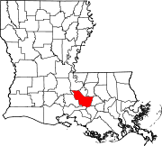
The community is in eastern Iberville Parish, on the west bank of the Mississippi River. It is 3.5 miles (5.6 km) north of White Castle and 7 miles (11 km) southeast of Plaquemine, the parish seat. According to the U.S. Census Bureau, the CDP has an area of 2.9 square miles (7.5 km2), of which 2.4 square miles (6.3 km2) are land and 0.46 square miles (1.2 km2), or 15.67%, are water, within the Mississippi River.[2]
References
- ^ U.S. Geological Survey Geographic Names Information System: Bayou Goula, Louisiana
- ^ a b "Geographic Identifiers: 2010 Census Summary File 1 (G001): Bayou Goula CDP, Louisiana". American Factfinder. U.S. Census Bureau. Retrieved April 4, 2018.


