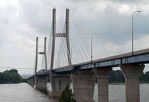
Bayview Bridge
Appearance
Bayview Bridge | |
|---|---|
 | |
| Coordinates | 39°56′00″N 91°25′17″W / 39.93333°N 91.42139°W |
| Carries | 2 lanes of Westbound |
| Crosses | Mississippi River |
| Locale | West Quincy, Missouri Quincy, Illinois |
| Other name(s) | Quincy Bayview Bridge |
| Maintained by | Illinois Department of Transportation |
| Characteristics | |
| Design | Cable-stayed bridge |
| Total length | 4,507 feet (1,374 m) |
| Width | 27 feet (8 m) |
| Longest span | 900 feet (274 m) |
| Clearance below | 63 feet (19 m) |
| History | |
| Opened | August 22, 1987 |
| Location | |
 | |
The Bayview Bridge is a cable-stayed bridge bringing westbound U.S. Route 24 (US 24) over the Mississippi River. It connects the cities of West Quincy, Missouri and Quincy, Illinois. Eastbound US 24 is served by the older Quincy Memorial Bridge.
The bridge was built at a cost of $32 million, $3 million over budget, to alleviate traffic over the downstream Memorial Bridge. It was built before the extension of Interstate 72 (I-72) west into Hannibal, Missouri. Traffic levels increased when the existing, downstream US 36 bridge over the Mississippi River was closed to make room for the new I-72 bridge.
See also
References
- Bayview Bridge at Structurae. Retrieved January 14, 2006.
- Weeks III, John A. "US-24 Quincy Bayview & Memorial Bridges Quincy, MO" [sic]. http://www.johnweeks.com/upper_mississippi/pagesB/umissB13.html. Retrieved January 14, 2006.
- Modjeski and Masters. "Bayview". https://web.archive.org/web/20051221194459/http://www.modjeski.com:80/projects/servproj/bayview.htm. Retrieved January 14, 2006.
- Unknown. "Should we build a new bridge?" WQAD. November 26, 2003. Retrieved January 14, 2006.
Categories:
- Cable-stayed bridges in the United States
- Bridges over the Mississippi River
- Towers in Illinois
- Road bridges in Illinois
- Bridges on the United States Numbered Highways
- Road bridges in Missouri
- Towers in Missouri
- Quincy–Hannibal Area
- Bridges completed in 1987
- U.S. Route 24
- Buildings and structures in Quincy, Illinois
- Buildings and structures in Marion County, Missouri
- 1987 establishments in the United States
- Illinois bridge (structure) stubs
- Midwestern United States bridge (structure) stubs
- Missouri building and structure stubs
- Missouri transportation stubs
