Ben Lomond bioregion
Appearance
| Ben Lomond Tasmania | |||||||||||||||
|---|---|---|---|---|---|---|---|---|---|---|---|---|---|---|---|
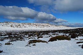
 Part of the Ben Lomond snowfields | |||||||||||||||
 | |||||||||||||||
| Area | 657 km2 (253.7 sq mi) | ||||||||||||||
| |||||||||||||||
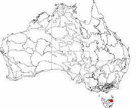
Ben Lomond is an interim Australian bioregion located in the north eastern region of Tasmania, comprising 657,500 hectares (1,625,000 acres).[1][2]
See also
References
- ^ "Interim Biogeographic Regionalisation for Australia (IBRA7) regions and codes". Department of Sustainability, Environment, Water, Population and Communities. Australian Government. 2012. Retrieved 13 January 2013.
- ^ "Interim Biogeographic Regionalisation for Australia, Version 7" (PDF). Department of Sustainability, Environment, Water, Population and Communities. Australian Government. 2012. Retrieved 14 April 2015.
Further reading
- Thackway, R.; Cresswell, I. D. (1995). An interim biogeographic regionalisation for Australia : a framework for setting priorities in the National Reserves System Cooperative Program, Version 4.0. Canberra: Australian Nature Conservation Agency, Reserve Systems Unit. ISBN 0-642-21371-2.
