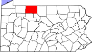
Big Shanty, Pennsylvania
Appearance
Big Shanty, Pennsylvania | |
|---|---|
Unincorporated community | |
| Coordinates: 41°50′15″N 78°39′17″W / 41.83750°N 78.65472°W | |
| Country | United States |
| State | Pennsylvania |
| County | McKean |
| Elevation | 2,096 ft (639 m) |
| Time zone | UTC-5 (Eastern (EST)) |
| • Summer (DST) | UTC-4 (EDT) |
| Area code | 814 |
| GNIS feature ID | 1209422[1] |
Big Shanty is an unincorporated community in Lafayette Township, McKean County, Pennsylvania, United States.[1] The community is 2.3 miles (3.7 km) south of Lewis Run; it was once connected to Lewis Run by Pennsylvania Route 823, which is now a county road.
References


