Borgoforte
Appearance
Borgoforte | |
|---|---|
| Comune di Borgoforte | |
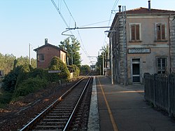
 View of Borgoforte's train station. | |
| Country | Italy |
| Region | Lombardy |
| Province | Mantua (MN) |
| Frazioni | Boccadiganda, Pioppelle, Romanore, San Cataldo, San Nicolò Po, Scorzarolo |
| Government | |
| • Mayor | Gianfranco Allegretti |
| Area | |
• Total | 38.9 km2 (15.0 sq mi) |
| Elevation | 19 m (62 ft) |
| Population (Dec. 2004)[2] | |
• Total | 3,419 |
| • Density | 88/km2 (230/sq mi) |
| Time zone | UTC+1 (CET) |
| • Summer (DST) | UTC+2 (CEST) |
| Postal code | 46030 |
| Dialing code | 0376 |
Borgoforte was a comune (municipality) in the Province of Mantua in the Italian region Lombardy, located about 130 kilometres (81 mi) southeast of Milan and about 14 kilometres (9 mi) southwest of Mantua.
It is home to a Rocca (castle or fortress), founded by the House of Gonzaga in the 13th century. After various vicissitudes, it was an important stronghold of the Austrian Empire in the Kingdom of Lombardy-Venetia, being captured by Italian troops during the Third Italian Independence War in 1866.
In 2014 it was annexed by Virgilio which became the municipality of Borgo Virgilio.
References
- ^ "Superficie di Comuni Province e Regioni italiane al 9 ottobre 2011". Italian National Institute of Statistics. Retrieved 16 March 2019.
- ^ All demographics and other statistics: Istituto Nazionale di Statistica (Istat).

