Boulouparis
Bouloupari | |
|---|---|
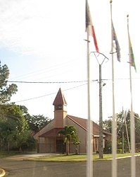
 The church of Bouloupari | |
 Location of the commune (in red) within New Caledonia | |
| Coordinates: 21°52′02″S 166°02′39″E / 21.8672°S 166.0442°E | |
| Country | France |
| Sui generis collectivity | New Caledonia |
| Province | South Province |
| Government | |
| • Mayor | Alain Lazare |
| Area 1 | 865.6 km2 (334.2 sq mi) |
| Population (2014 census) | 3,005 |
| • Density | 3.5/km2 (9.0/sq mi) |
| Ethnic distribution | |
| • 1996 census | Kanaks 44.2% Europeans 42.8% Polynesians 5.7% Other 7.3% |
| Time zone | UTC+11:00 |
| INSEE/Postal code | 98802 /98812 |
| Elevation | 0–1,441 m (0–4,728 ft) (avg. 20 m or 66 ft) |
| 1 New Caledonia Land Register (DITTT) data, which exclude lakes and ponds larger than 1 km² (0.386 sq mi or 247 acres) as well as the estuaries of rivers. | |
Bouloupari (locally spelled Boulouparis, but this spelling is not recognized by French authorities) is a commune in the South Province of New Caledonia, an overseas territory of France in the Pacific Ocean.
Wikimedia Commons has media related to Boulouparis.

