Bristol Channel


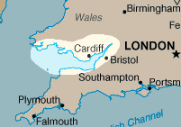
The Bristol Channel (Welsh: Môr Hafren) is a major inlet in the island of Great Britain, separating South Wales from South West England and extending from the lower estuary of the River Severn to that part of the North Atlantic Ocean known as the Celtic Sea. It takes its name from the English city of Bristol and is over 50km across at its widest point.
Ecology
At low tide large parts of the channel may become mud flats due to the estuaries tidal range of 15 metres, the second largest in the world. A result of this tidal range is the famous Severn Bore, creating a spectacular rush of water upstream. The estuary is an important area for wildlife, in particular waders, and has protected areas, including National Nature Reserves. Development schemes have been proposed along the channel, including an airport and a tidal barrier for electricity generation, but the conservation issues have always blocked such schemes.
Major islands in the Bristol Channel are Lundy, Steep Holm and Flat Holm. The islands and headlands provide some shelter for the upper reaches of the channel from storms. These islands are mostly uninhabited and protected as nature reserves, and are home to some unique wild flower species.
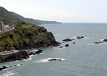
Arguably, the Bristol Channel has better beaches and more spectacular scenery than the equivalent English Channel, particularly on the coast of Exmoor and Bideford Bay in Devon and the likes of the Vale of Glamorgan and the Gower Peninsula in Wales. The western stretch of Exmoor boasts the highest cliffs in mainland Britain, culminating in the gigantic 'Great Hangman', a 1043ft 'hog-backed' hill with a cliff-face of 820ft; its sister cliff 'The Little Hangman' has a cliff-face of 716ft. On the Gower Peninsula, at its western extremity is the surreal Worms Head, a serpent shaped island of carboniferous limestone which is approachable at low tide only. The beaches of both Gower and North Devon, for example Woolacombe and Rhossili win leigons of awards for their water quality and setting, as well as their excellent surf.
Coastal cities and towns
The Bristol Channel is a notoriously dangerous area of water because of its strong tides and the rarity of havens on the north Cornish and north Devon coasts that can be entered in all states of the tide. A sailor's rhyme goes "Twixt Hartland Point and Padstow Bay is a sailor's grave by night or day." because of the treacherous waters, pilotage was (and remains) an essential service for shipping. A specialised style of sailing boat the Bristol Channel Pilot Cutter developed in the area, producing some of the most seaworthy sailing vessels in the world.
In the estuary above Avonmouth, river rescue is provided by Severn Area Rescue Association.
Situated on the River Avon is the city of Bristol, from which the Channel takes its name and which was once one of the most important ports in Britain. There are still docks in the city centre, but these are largely now given over to leisure use. Bristol's dock activity has now been transferred to the nearby Channel coast at Avonmouth Docks and Royal Portbury Dock. Resort towns include Portishead, Clevedon, Burnham on Sea, Weston-super-Mare, Minehead, Watchet, Porlock in Somerset, and Ilfracombe, Bideford and Barnstaple in Devon.

The Welsh capital, Cardiff, is on the northern side side of the estuary, home of the Welsh Assembly building and the Wales Millennium Centre. Further west is the city of Swansea with a fine marina. Important ports on the Welsh coast include Milford Haven, a major oil import terminal. Resort towns and villages on the Welsh coastline include Penarth, Llantwit Major, Mumbles and Barry with Barry Island. The city of Newport on the estuary of the River Usk is an important administrative, industrial and docks centre, famous for its transporter bridge. Chepstow is an ancient fort town, with a fine castle.
Transport
Rail
The Severn Tunnel, situated near the Second Severn Crossing road bridge, carries the railway line under the channel.
Road
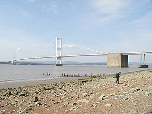
At two of the narrower parts, near Bristol and Chepstow, the channel is crossed by the:
- Severn Bridge - opened in 1966 carrying the M48
- Second Severn Crossing opened in 1996 carrying the M4 motorway
Previous to the construction of the first bridge in 1966, the channel was crossed by the Aust ferry.
Paddle Steamers
P and A Campbell of Bristol were the main operators of pleasure craft and particularly paddle steamerss, from the mid-1800s to the late 1970s, also the Barry Railway Company. This tradition is continued each summer by the PS Waverley, the last sea-going paddle steamer in the world (built in 1947). The steamer provides pleasure trips between the Welsh and English coasts and to the islands of the channel.
Severn Barrage
The proposed Severn Barrage would constitute a third crossing, and would have a significant environmental impact on the Severn estuary and Bristol Channel.
1607 flood
- Main article: Bristol Channel floods, 1607
On 30 January 1607 (New style) thousands of people were drowned, houses and villages swept away, farmland inundated and flocks destroyed when a flood hit the shores of the channel. The devastation was particularly bad on the Welsh side from Laugharne in Carmarthenshire to above Chepstow on the English border. Cardiff was the most badly affected town. There remain plaques up to 8ft above sea level to show how high the waters rose on the sides of the surviving churches. It was commemorated in a contemporary pamphlet "God's warning to the people of England by the great overflowing of the waters or floods."
The cause of the flood is disputed: it had long been believed that the floods were caused by a combination of meteorological extremes and tidal peaks, but research published in 2002 has shown evidence of a tsunami in the Channel.
