Brody, Żary County
Brody | |
|---|---|
Village | |
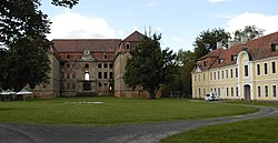
 Brühl palace | |
| Coordinates: 51°47′25″N 14°46′26″E / 51.79028°N 14.77389°E | |
| Country | |
| Voivodeship | Lubusz |
| County | Żary |
| Gmina | Brody |
| Population | 1,070 |
Brody [ˈbrɔdɨ] (Lower Sorbian: Brody,[citation needed] German: Pförten) is a village in Żary County, Lubusz Voivodeship, in western Poland, close to the German border. It is the seat of the gmina (administrative district) called Gmina Brody.[1] It lies approximately 31 kilometres (19 mi) north-west of Żary and 53 km (33 mi) west of Zielona Góra. The village has a population of 1,070.
History
The village in the historic Lower Lusatia region passed from the Kingdom of Bohemia to the Electorate of Saxony by the 1635 Peace of Prague. From 1740 it was a possession of the Saxon statesman Heinrich von Brühl, who had an extended Baroque palace built, where he received Elector Frederick Augustus II of Wettin and kept his famous Meissen porcelain Swan Service tableware of more than 2,000 pieces designed by Johann Joachim Kaendler. The palace was devastated by Prussian troops by the explicit command of King Frederick II of Hohenzollern during the Seven Years' War.
By the Final Act of the Vienna Congress in 1815 Pförten with Lower Lusatia fell to Prussia and before 1945 the area was part of Germany (see Territorial changes of Poland after World War II). The Brühl Palace, again ravaged by the Red Army, has in parts been rebuilt.
Notable people
- Carl von Brühl (1772–1837)
- Theresia Anna Maria von Brühl (1784–1844)
- Hermann Ulrici (1806–1884), philosopher
- Friedrich-August Graf von Brühl (1913–1981), Wehrmacht officer
International relations
Twin towns — Sister cities
Brody is twinned with:
 Lubsko, Poland
References


