
Brohl-Lützing
Brohl-Lützing | |
|---|---|
 Train station | |
 Coat of arms | |
Location of Brohl-Lützing within Ahrweiler district  | |
 Brohl-Lützing  Brohl-Lützing | |
| Coordinates: 50°29′6″N 7°19′45″E / 50.48500°N 7.32917°E | |
| Country | Germany |
| State | Rhineland-Palatinate |
| District | Ahrweiler |
| Municipal assoc. | Bad Breisig |
| Government | |
| • Mayor | Christel Ripoll (CDU) |
| Area | |
| • Total | 9.23 km2 (3.56 sq mi) |
| Elevation | 70 m (230 ft) |
| Population (2022-12-31)[1] | |
| • Total | 2,511 |
| • Density | 270/km2 (700/sq mi) |
| Time zone | UTC+01:00 (CET) |
| • Summer (DST) | UTC+02:00 (CEST) |
| Postal codes | 56656 |
| Dialling codes | 02633 (Brohl), 02636 (Niederlützingen) |


Brohl-Lützing is a municipality in the district of Ahrweiler in Rhineland-Palatinate, Germany.
-
 Rheinburgenweg Trail and Rheinhöhenweg Trail
 -
 Hiking trail „Eselstreppe“
 -
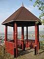 Viewpoint


References
- ^ "Bevölkerungsstand 2022, Kreise, Gemeinden, Verbandsgemeinden" (PDF) (in German). Statistisches Landesamt Rheinland-Pfalz. 2023.

| International | |
|---|---|
| National | |
This Ahrweiler location article is a stub. You can help Wikipedia by expanding it. |