
Cactus Flat, South Dakota
Cactus Flat, South Dakota | |
|---|---|
 Cactus Flat, South Dakota | |
| Coordinates: 43°50′08″N 101°53′40″W / 43.83556°N 101.89444°W | |
| Country | United States |
| State | South Dakota |
| County | Jackson |
| Elevation | 2,500 ft (800 m) |
| Time zone | UTC-7 (Mountain (MST)) |
| • Summer (DST) | UTC-6 (MDT) |
| Area code | 605 |
| GNIS feature ID | 1261390[1] |
Cactus Flat (also Cactus Flat Junction, Cactus Flats) is an unincorporated community in Jackson County, South Dakota, United States.[1]
Notes
Municipalities and communities of Jackson County, South Dakota, United States | ||
|---|---|---|
| City | 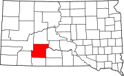 | |
| Towns | ||
| CDP | ||
| Former CDP | ||
| Unincorporated communities | ||
| Indian reservation | ||
| Ghost town | ||
| Footnotes | ‡This populated place also has portions in an adjacent county or counties | |
This South Dakota state location article is a stub. You can help Wikipedia by expanding it. |