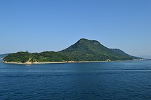
Cape Nagasakibana
Appearance
Nagasakibana (長崎鼻, Nagasakibana) is a common name used for various headlands in Japan. They may also known as Cape Nagasakibana (長崎鼻岬, Nagasakibana Misaki). The name is also used for the geothermal area in Ibusuki associated with Cape Nagasakibana, Kagoshima,[1] and its coastal area.[2] This coastal area of 55 km2 (21 sq mi) is a loggerhead sea turtle feeding ground at the southern limit in Japan of eel grass beds.[3]
The name of the city Nagasaki (長崎, Nagasaki) means long cape and 鼻 means nose in Japanese,[4] so helping to explain further this English language wide use in names of geographical features.
These headlands include:
References
[edit]- ^ Yuhara, K; Ushijima, K (1977). "Ground temperature surveys and thermal discharge measurements at Ibusuki and its surrounding geothermal areas". Chishitsu Chosasho Geppo; (Japan). 28 (1): 33–56. Retrieved 23 September 2023.
- ^ Mutagami, Muneyuki; Ryuichiro, Nishi; Takaaki, Uda (2001). "Optimal design of artificial reefs in a pocket beach at Nagasakibana, Japan". Coastal Dynamics. 1: 36–45. doi:10.1061/40566(260)4. ISBN 978-0-7844-0566-6.
- ^ "Coastal Area 15205 Adjacent waters of Ibusuki, Cape Nagasakibana". www.env.go.jp/en/index.html. Retrieved 23 September 2023.
- ^ "Japanese Names Info:Nagasaki". japanese-names.info. Retrieved 7 November 2023.
- ^ "Cape Nagasakibana". www.japan-guide.com. Retrieved 2022-10-02.
- ^ "Nagasaki no Hana Kofun". www.yashima-navi.jp. Retrieved 16 July 2023.
- ^ a b "Goto Islands". www.discover-nagasaki.com. Retrieved 2022-01-20.
- ^ "対馬長崎鼻灯台 (Tsushima Nagasakibana Lighthouse)". Retrieved 7 November 2023.
- ^ "長崎鼻". Retrieved 7 November 2023.
- ^ "長崎鼻 Observation Deck". Retrieved 7 November 2023.
- ^ "OJIKA ISLAND". ojikajima.jp. Retrieved 5 October 2022.
- ^ "Tokawa, a Small Port Town in Chiba:Nagasakibana Area". uj-tours.com. 20 October 2017. Retrieved 16 July 2023.
- ^ "Nagasakibana". www.ana.co.jp. Retrieved 16 Jul 2023.


