Caughnawaga Indian Village Site
Caughnawaga Indian Village Site | |
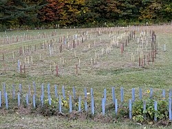
 Site of Caughnawaga with stakes marking the lines of the stockade and long houses. | |
| Nearest city | Fonda, New York |
|---|---|
| Coordinates | 42°57′6.516″N 74°23′25.9836″W / 42.95181000°N 74.390551000°W |
| Area | 135 acres (55 ha) |
| Built | 1666 (or 1679) |
| NRHP reference No. | 73001207[1] |
| Added to NRHP | August 28, 1973 |
Caughnawaga Indian Village Site (also known as the Veeder site) is an archaeological site located just west of Fonda in Montgomery County, New York. The location of a former Mohawk nation village, the site was discovered in 1950 by Rev. Thomas Grassmann. It is the only completely excavated Iroquois village in the country.
The Mohawk village site has been marked with stakes to show the outlines of the 12 longhouses and stockade that were built there 300 years ago. The entire site is open to the public, so people may walk around the former village and see the foundations of the Caughnawaga longhouses and the layout. The site is on a hill. The archeological site was listed on the National Register of Historic Places in 1973.[1]
Below it have been constructed the Mohawk-Caughnawaga museum and the National Shrine of Blessed Kateri Tekakwitha, canonized in the 20th century as the first Native American saint in the Roman Catholic Church.[2]
The name Caughnawaga is derived from the Mohawk word kahnawà:ke, meaning "place of the rapids", referring to the rapids of the Mohawk River.[3]
It is also known as Indian Castle, or Gandaouage; or Kachnawage in Mohawk, meaning "castle" or "fortified place." This village with its defensive palisade was the Native American form of a castle. The site overlooks the Mohawk River and is also close to a natural spring.[4]
Caughnawaga was occupied by the Mohawk from 1666 to 1693. French Jesuits established a mission there, which operated for about 10 years ranging from 1668 to 1679; they taught some of the Mohawk to read and write in French, as well as teaching them about Christianity. It is now believed that the village known as "Caughnawaga" was located upstream at the "Fox Farm site" until 1679, at which time it moved to this location. Snow gives a population estimate of around 300 people, fewer than had lived at the Fox Farm site due to the departure of the Catholic Mohawks to Canada by 1679.[5]
The site is now a center for recreation and culture.
Gallery
-
Interpretive sign for Caughnawaga site
References
- ^ a b "National Register Information System". National Register of Historic Places. National Park Service. March 13, 2009.
- ^ "Kateri Tekawitha and Mohawak-Caughnawaga Indian National Shrine", Adirondack North Country Association website
- ^ Bright, William (2004). Native American placenames of the United States. University of Oklahoma Press. p. 84. ISBN 978-0-8061-3598-4. Retrieved 11 April 2011.
- ^ Caughnawaga Indian Village Site
- ^ Snow, Dean (1995). Mohawk Valley Archaeology: The Sites (PDF). Matson Museum of Archaeology, Penn State University. ISBN 0-9647913-0-7. Retrieved May 2, 2016.
External links
- Archaeological sites on the National Register of Historic Places in New York
- Iroquois populated places
- Former Native American populated places in the United States
- Mohawk tribe
- Native American history of New York
- Buildings and structures in Montgomery County, New York
- Visitor attractions in Montgomery County, New York
- National Register of Historic Places in Montgomery County, New York


