
Cedar Avenue station
Cedar Avenue | |||
|---|---|---|---|
| Station statistics | |||
| Borough | Staten Island | ||
| Coordinates | 40°35′48″N 74°03′56″W / 40.596583°N 74.065639°W | ||
| Division | [1] | ||
| Line | South Beach Branch | ||
| Services | none | ||
| Platforms | 2 side platforms | ||
| Tracks | 2 | ||
| Other information | |||
| Opened | 1934 | ||
| Closed | March 31, 1953 | ||
| Traffic | |||
| 2023 | [2] | ||
| Rank | out of 423[2] | ||
| Station succession | |||
| Next north | Arrochar | ||
| Next south | South Beach | ||
| |||
| |||


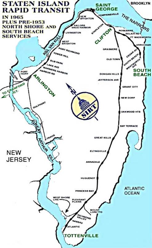
Cedar Avenue was a station on the demolished South Beach Branch of the Staten Island Railway. It had two tracks and two side platforms and was located at Cedar Avenue and Railroad Avenue.
History
The station opened as part of a grade crossing elimination project on the South Beach Branch.[3] This station was abandoned when the SIRT discontinued passenger service on the South Beach Branch to South Beach at midnight on March 31, 1953 because of city-operated bus competition.[4][5][6] The platforms continued to remain on this location into the 1960s.[7]
South of this station is the Robin Road Trestle, which is the only remaining intact trestle along the South Beach Line. In the early 2000s developers purchased the property on either side of the trestle's abutments, but the developers, the New York City Department of Transportation, and the New York City Transit Authority all claimed ownership of it. Consequently, townhouses have built up against both sides of it.[8][9][10][11]
References
- ^ "Glossary". Second Avenue Subway Supplemental Draft Environmental Impact Statement (SDEIS) (PDF). Vol. 1. Metropolitan Transportation Authority. March 4, 2003. pp. 1–2. Archived from the original (PDF) on February 26, 2021. Retrieved January 1, 2021.
- ^ a b "Annual Subway Ridership (2018–2023)". Metropolitan Transportation Authority. 2023. Retrieved April 20, 2024.
- ^ Bommer, Edward (2003). Stations and Places Along the Staten Island Rapid Transit. Retrieved November 19, 2015.
- ^ Pitanza, Marc (2015). Staten Island Rapid Transit Images of Rail. Arcadia Publishing. ISBN 978-1-4671-2338-9.
- ^ Drury, George H. (1994). The Historical Guide to North American Railroads: Histories, Figures, and Features of more than 160 Railroads Abandoned or Merged since 1930. Waukesha, Wisconsin: Kalmbach Publishing. pp. 312–314. ISBN 0-89024-072-8.
- ^ "The Old Order Passeth: Rails Surrender To Roads: Passenger Runs on Two Lines of SIRT Will End at Midnight". Staten Island Advance. March 31, 1953. Retrieved October 14, 2015.
- ^ "Gary Owen's SIRT Page". Gary Owen Land. March 31, 1953. Retrieved November 19, 2015.
- ^ "STATEN ISLAND RAILWAY". Forgotten New York. March 29, 2012. Retrieved October 8, 2015.
- ^ Arrochar and South Beach: In the Shadow of the 'Zano Archived July 7, 2012, at archive.today.
- ^ Advance, Staten Island (December 7, 2008). "Permission to dream". SILive.com. Retrieved October 8, 2015.
- ^ "Gary Owen SIRT Page Part Two". Gary Owen Land. April 20, 1937. Retrieved October 8, 2015.
This Staten Island train station–related article is a stub. You can help Wikipedia by expanding it. |