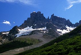
Cerro Castillo National Park
| Cerro Castillo National Reserve | |
|---|---|
IUCN category IV (habitat/species management area) | |
 | |
| Location | Aysén del General Carlos Ibáñez del Campo Region, Chile |
| Nearest city | Balmaceda |
| Coordinates | 46°03′S 72°11′W / 46.050°S 72.183°W |
| Area | 1,795.5 km2 [1] |
| Established | 1970 |
| Governing body | Corporación Nacional Forestal |
Cerro Castillo National Reserve is a nature reserve of Chile located in the Aysén del General Carlos Ibáñez del Campo Region, south of Coyhaique. The reserve is named after Cerro Castillo, its highest mountain and main attraction. The Carretera Austral passes through the reserve.
Mammals in the reserve include South Andean deer, guanacos, pumas and canines of the genus Lycalopex. Notable birds that inhabit in the area are the austral parakeet and the Andean condor.[1]Lenga is the most common tree species in the reserve.[1]
The northern portion of the reserve is part of Aisén River drainage basin, whereas that the southern portion is included in the basin area of Ibáñez River.
References
Wikimedia Commons has media related to Cerro Castillo National Reserve.
