
Cherry Lane, North Carolina
Cherry Lane, North Carolina | |
|---|---|
| Country | United States |
| State | North Carolina |
| County | Alleghany |
| Time zone | Eastern (EST) |
| • Summer (DST) | EDT |
| ZIP codes | 28668 |
Cherry Lane is an unincorporated community located in the Cherry Lane Township of Alleghany County, North Carolina. The community was settled around 1838 and was named for the cherry tree-bordered lane that led to the home of local resident Frank Bryan (Powell 1968, p. 102). The community is located along US Highway 21 near its junction with the Blue Ridge Parkway in southeastern Alleghany County.
See also
References
- Powell, William S. (1968), The North Carolina Gazetteer: A Dictionary of Tar Heel Places, Chapel Hill: University of North Carolina Press, ISBN 0-8078-1247-1
36°26′31″N 81°01′05″W / 36.4420759°N 81.0181349°W
Municipalities and communities of Alleghany County, North Carolina, United States | ||
|---|---|---|
| Town | 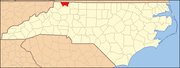 | |
| Townships | ||
| Unincorporated communities | ||