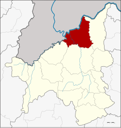
Chiang Khan district
This article needs additional citations for verification. (July 2016) |
Chiang Khan
เชียงคาน | |
|---|---|
 Amphoe location in Loei Province | |
| Coordinates: 17°53′53″N 101°39′59″E / 17.89806°N 101.66639°E | |
| Country | Thailand |
| Province | Loei |
| Seat | Chiang Khan |
| Area | |
| • Total | 867.0 km2 (334.8 sq mi) |
| Population (2005) | |
| • Total | 59,016 |
| • Density | 68.1/km2 (176/sq mi) |
| Time zone | UTC+7 (ICT) |
| Postal code | 42110 |
| Geocode | 4203 |
Chiang Khan (Thai: เชียงคาน, pronounced [t͡ɕʰīa̯ŋ kʰāːn]) is a district (amphoe) in the northern part of Loei Province, northeastern Thailand.
Geography
Neighboring districts are (from the east clockwise) Pak Chom, Mueang Loei, and Tha Li of Loei Province. To the northwest are the Xaignabouli and Vientiane Provinces of Laos.
The important water resources are the Mekong, Hueang and Loei Rivers.
History
Chiang Khan was founded in the late-19th century when Lao villagers crossed the Mekong after the French colonised Laos. More migrants later arrived from Vietnam and China. Chiang Khan became a trading hub largely due to its location on the river. People on both sides of the rivers exchanged goods, culture, and language. Trading stopped in 1975 when the communist Pathet Lao seized power from the Lao government and cut economic ties to Thailand. Chiang Khan languished until rediscovered in the early-21st century.[1]
Administration
The district is divided into eight sub-districts (tambon), which are further subdivided into 78 villages (muban). There are two townships (thesaban tambon), Chiang Khan and Khao Kaeo, each covering parts of tambon of the same names. There are a further seven tambon administrative organizations (TAO).
| No. | Name | Thai name | Villages | Pop. | |
|---|---|---|---|---|---|
| 1. | Chiang Khan | เชียงคาน | 6 | 10,245 | |
| 2. | That | ธาตุ | 15 | 9,523 | |
| 3. | Na Sao | นาซ่าว | 15 | 11,453 | |
| 4. | Khao Kaeo | เขาแก้ว | 13 | 7,596 | |
| 5. | Pak Tom | ปากตม | 7 | 5,967 | |
| 6. | Bu Hom | บุฮม | 10 | 7,528 | |
| 7. | Chom Si | จอมศรี | 7 | 4,301 | |
| 8. | Hat Sai Khao | หาดทรายขาว | 5 | 2,403 |
Economy
Fishing the Mekong River was formerly Chiang Khan's biggest earner. Declining catches have ruined that. As recently as ten years ago, 100 families derived their income from fishing. Today that number has declined to roughly 40 families. Chiang Khan has now been discovered by tourists. Some 650,000 persons, Thai and foreign, visit the village every year.[1]
References
- ^ a b Wangkiat, Paritta (24 July 2016). "Caught up in a tourist trap". Bangkok Post. Retrieved 24 July 2016.
External links
- amphoe.com (Thai)
- Chiangkhan
