
Citadel Mountain
| Citadel Mountain | |
|---|---|
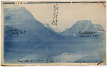
 Citadel Mountain rises above Saint Mary Lake in the center of the picture in the distance | |
| Highest point | |
| Elevation | 9,035 ft (2,754 m) NAVD 88[1] |
| Prominence | 2,150 ft (660 m)[1] |
| Parent peak | Little Chief Mountain[1] |
| Geography | |
 Citadel Mountain | |
| Location | Glacier County, Montana, U.S. |
| Parent range | Lewis Range |
| Topo map | USGS Logan Pass |
| Climbing | |
| First ascent | 1939 by Dyson, Iverson and Lindsey[1] |
| Easiest route | Strenuous hike, class 2[3] |
Citadel Mountain (9,035 feet or 2,754 meters) is located in the Lewis Range, Glacier National Park in the U.S. state of Montana.[1] The mountain is located at the western edge of Saint Mary Lake and is easily seen from the Going-to-the-Sun Road.
See also
References
- ^ a b c d e "Citadel Mountain, Montana". Peakbagger.com. Retrieved 2010-03-07.
- ^ "Citadel Mountain". Geographic Names Information System. United States Geological Survey, United States Department of the Interior. Retrieved 2010-09-26.
- ^ "Citadel Mountain". SummitPost.org. Retrieved 2014-03-22.
This Montana state location article is a stub. You can help Wikipedia by expanding it. |