Clarkston, Utah
Clarkston, Utah | |
|---|---|
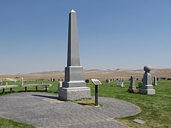
 The Martin Harris Gravesite in Clarkston is listed on the National Register of Historic Places | |
 Location in Cache County and the state of Utah. | |
| Coordinates: 41°55′8″N 112°2′58″W / 41.91889°N 112.04944°W | |
| Country | United States |
| State | Utah |
| County | Cache |
| Founded | 1864 |
| Named for | Israel Justus Clark |
| Area | |
| • Total | 1.0 sq mi (2.5 km2) |
| • Land | 1.0 sq mi (2.5 km2) |
| • Water | 0.0 sq mi (0.0 km2) |
| Elevation | 4,879 ft (1,487 m) |
| Population (2012) | |
| • Total | 679 |
| • Density | 718.0/sq mi (277.2/km2) |
| Time zone | UTC-7 (Mountain (MST)) |
| • Summer (DST) | UTC-6 (MDT) |
| ZIP code | 84305 |
| Area code | 435 |
| FIPS code | 49-13190[2] |
| GNIS feature ID | 1426671[1] |
Clarkston is a town in Cache County, Utah, United States. The population was 666 at the 2010 census. It is included in the Logan, Utah-Idaho Metropolitan Statistical Area.
Clarkston is noted for being the last home of Martin Harris, one of the Three Witnesses of the Book of Mormon. He is buried in Clarkston and every other year a pageant commemorates his life.[3]
History
The townsite of Clarkston was laid out in 1864.[4] It was named for Israel Justus Clark, who was an early settler and the first branch president of The Church of Jesus Christ of Latter-day Saints in Clarkston.[5] A Latter-day Saint ward was organized in Clarkston in the fall of 1867 with William F. Rigby as bishop.[6] A brick meetinghouse was built in 1910.[6] In 1930 Clarkston had a population of 570.[6]
Geography
According to the United States Census Bureau, the town has a total area of 1 square mile (2.6 km2), all of it land.
Demographics
| Census | Pop. | Note | %± |
|---|---|---|---|
| 1870 | 153 | — | |
| 1880 | 464 | 203.3% | |
| 1890 | 440 | −5.2% | |
| 1900 | 475 | 8.0% | |
| 1910 | 564 | 18.7% | |
| 1920 | 528 | −6.4% | |
| 1930 | 570 | 8.0% | |
| 1940 | 579 | 1.6% | |
| 1950 | 526 | −9.2% | |
| 1960 | 490 | −6.8% | |
| 1970 | 420 | −14.3% | |
| 1980 | 562 | 33.8% | |
| 1990 | 645 | 14.8% | |
| 2000 | 688 | 6.7% | |
| 2010 | 666 | −3.2% | |
| 2016 (est.) | 711 | [7] | 6.8% |
| U.S. Decennial Census[8] | |||
As of the census[2] of 2000, there were 688 people, 206 households, and 172 families residing in the town. The population density was 718.0 people per square mile (276.7/km²). There were 219 housing units at an average density of 228.6 per square mile (88.1/km²). The racial makeup of the town was 95.78% White, 0.29% Native American, 1.60% from other races, and 2.33% from two or more races. Hispanic or Latino of any race were 2.18% of the population.
There were 206 households out of which 47.1% had children under the age of 18 living with them, 76.7% were married couples living together, 4.9% had a female householder with no husband present, and 16.5% were non-families. 16.0% of all households were made up of individuals and 9.2% had someone living alone who was 65 years of age or older. The average household size was 3.34 and the average family size was 3.78.
In the town, the population was spread out with 35.5% under the age of 18, 10.9% from 18 to 24, 23.4% from 25 to 44, 19.8% from 45 to 64, and 10.5% who were 65 years of age or older. The median age was 28 years. For every 100 females, there were 108.5 males. For every 100 females age 18 and over, there were 100.9 males.
The median income for a household in the town was $40,592, and the median income for a family was $42,171. Males had a median income of $32,344 versus $20,000 for females. The per capita income for the town was $13,626. None of the families and 0.7% of the population were living below the poverty line, including no under eighteens and 7.2% of those over 64.
Notable people
- William Williams Henderson, educator
- LaFarr Stuart, computer music pioneer
- Martin Harris, Mormon pioneer
References
- ^ a b U.S. Geological Survey Geographic Names Information System: Clarkston
- ^ a b "American FactFinder". United States Census Bureau. Archived from the original on 2013-09-11. Retrieved 2008-01-31.
{{cite web}}: Unknown parameter|deadurl=ignored (|url-status=suggested) (help) - ^ http://www.lds.org/placestovisit/location/0,10634,1784-1-1-1,00.html
- ^ Jenson, Andrew. Encyclopedic History of the Church of Jesus Christ of Latter-day Saints (Salt Lake City: Deseret News Press, 1941) p. 143
- ^ The Utah Genealogical and Historical Magazine, Volumes 9-10. 1918. p. 84.
- ^ a b c Jenson. Encyclopedic History. p. 143
- ^ "Population and Housing Unit Estimates". Retrieved June 9, 2017.
- ^ "Census of Population and Housing". Census.gov. Archived from the original on May 12, 2015. Retrieved June 4, 2015.
{{cite web}}: Unknown parameter|deadurl=ignored (|url-status=suggested) (help)

