Commewijne District
Appearance
Commewijne | |
|---|---|
 | |
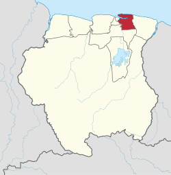
 Map of Suriname showing Commewijne district | |
| Country | Suriname |
| Capital | Nieuw Amsterdam |
| Area | |
| • Total | 2,353 km2 (908 sq mi) |
| Population (2012 census) | |
| • Total | 31.420 |
| • Density | 0.013/km2 (0.035/sq mi) |
| Time zone | UTC-3 (ART) |
Commewijne is a district of Suriname, located on the right bank of the Suriname River. Commewijne's capital city is Nieuw Amsterdam. Alliance is another major town.
The district has a population of 31,420 and an area of 2,353 km².
One of the most populated of Suriname's districts, Commewijne relies primarily on agriculture for its income, with plantations dating back to the first Dutch colonisation of the area in the 17th century.
Along with numerous small colonial forts, Nieuw Amsterdam is the home of Fort Nieuw-Amsterdam, a large fortress built to protect the Commewijne area during the Second Anglo-Dutch War.
Resorts

Commewijne is divided into 6 resorts (ressorten):

