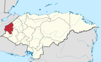
Copán Department
Appearance
Copán | |
|---|---|
Department | |
 | |
| Country | |
| Municipalities | 23 |
| Founded | 1869 |
| Seat | Santa Rosa de Copán |
| Government | |
| • Type | Departmental |
| Area | |
• Total | 3,242 km2 (1,252 sq mi) |
| Population (2015)[1] | |
• Total | 382,722 |
| • Density | 120/km2 (310/sq mi) |
| Time zone | -6 |
| Postal code | 41101, 41202 |
Copán is one of the departments in the western part of Honduras. The departmental capital is the town of Santa Rosa de Copán. The department is well known for its tobacco and fine cigars.
The department is famous for its Pre-Columbian archaeological site at Copán, one of the greatest cities of the Maya civilization.
The department of Copán covers a total surface area of 3,242 km2 and, in 2015, had an estimated population of about 382,722 people.
Municipalities
- Cabañas
- Concepción
- Copán Ruinas
- Corquín
- Cucuyagua
- Dolores
- Dulce Nombre
- El Paraíso
- Florida
- La Ruidosa
- La Unión
- Nueva Arcadia
- San Agustín
- San Antonio
- San Jerónimo
- San José
- San Juan de Opoa
- San Nicolás
- San Pedro de Copán
- Santa Rita
- Santa Rosa de Copán
- Trinidad de Copán
- Veracruz, Copán
14°46′N 88°47′W / 14.767°N 88.783°W
References
- ^ "GeoHive - Honduras extended". Retrieved 2015.
{{cite web}}: Check date values in:|accessdate=(help)
