Cornudella de Montsant
Cornudella de Montsant | |
|---|---|
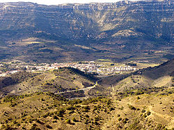
 The town with the massive escarpments in the background | |
| Coordinates: 41°16′01″N 0°54′22″E / 41.26694°N 0.90611°E | |
| Country | |
| Community | |
| Province | Tarragona |
| Comarca | Priorat |
| Government | |
| • Mayor | Salvador Salvadó Porqueres (2015)[1] |
| Area | |
| • Total | 63.5 km2 (24.5 sq mi) |
| Elevation | 533 m (1,749 ft) |
| Population (2014)[1] | |
| • Total | 954 |
| • Density | 15/km2 (39/sq mi) |
| Demonym | Cornudellenc |
| Postal code | 43360 |
| Website | www |

Cornudella de Montsant is a municipality in the comarca of the Priorat in Catalonia, Spain. It is situated in the north-west of the comarca below the Montsant range and the Prades Mountains. The Siurana reservoir is on the territory of the municipality and supplies its drinking water.
Sites near to the village include the Sant Joan del Codolar Hermitage. The village derives income from tourism and agriculture, particularly wine and hazelnuts. Cornudella de Montsant is at the centre of one of the world's major rock climbing regions.
History
In medieval times the town was part of the Barony of Entença.
The old winery of Cornudella de Montsant, also known in Catalonia as one of the 'Wine Cathedrals, was built during the Modernisme and Noucentisme periods and was designed by architect Cèsar Martinell.
References
- ^ a b "Ajuntament de Cornudella de Montsant". Generalitat of Catalonia. Retrieved 2015-11-13.
- ^ "El municipi en xifres: Cornudella de Montsant". Statistical Institute of Catalonia. Retrieved 2015-11-23.
- Panareda Clopés, Josep Maria; Rios Calvet, Jaume; Rabella Vives, Josep Maria (1989). Guia de Catalunya, Barcelona:Caixa de Catalunya. ISBN 84-87135-01-3 (Spanish). ISBN 84-87135-02-1 (Catalan).
External links
- Official website Template:Ca icon Template:Es icon Template:En icon
- Government data pages Template:Ca icon


