Crow Canyon Archaeological District
Appearance
This article lacks inline citations besides NRIS, a database which provides minimal and sometimes ambiguous information. (November 2013) |
Crow Canyon Archeological District | |
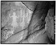
 Rock art at Crow Canyon | |
| Nearest city | Farmington, New Mexico |
|---|---|
| Coordinates | 36°32′49″N 107°37′00″W / 36.5470°N 107.6167°W |
| Area | 3,200 acres (1,300 ha) |
| Architectural style | Hogans & Pueblitos |
| NRHP reference No. | 74001200[1] |
| NMSRCP No. | 276 |
| Significant dates | |
| Added to NRHP | July 15, 1974 |
| Designated NMSRCP | March 20, 1973 |
Crow Canyon Archaeological District is a historic site in Rio Arriba and San Juan counties in New Mexico, about 30 miles southeast of the city of Farmington. Located in Dinétah, the traditional homeland of the Navajo people, the site contains a variety of Navajo ruins and rock art from the 16th, 17th, and 18th centuries. There are several large petroglyph panels which include both Navajo and Pueblo images, as well as a handful of Navajo defensive structures known as pueblitos which were built in the 18th century during a period of conflict with the Utes. The site was added to the National Register of Historic Places in 1974.

See also
- List of dwellings of Pueblo peoples
- National Register of Historic Places listings in Rio Arriba County, New Mexico
- National Register of Historic Places listings in San Juan County, New Mexico
References
External links
Wikimedia Commons has media related to Crow Canyon Archaeological District.
- Crow Canyon petroglyphs, 26 photographs from Historic American Buildings Survey
- Crow Canyon photographs, main panel area, 32 photographs, Summer, 2010
Categories:
- Ancient Pueblo peoples rock art
- Petroglyphs in New Mexico
- Native American history of New Mexico
- Archaeological sites on the National Register of Historic Places in New Mexico
- Bureau of Land Management areas in New Mexico
- Geography of Rio Arriba County, New Mexico
- Northern Rio Grande National Heritage Area
- Historic districts on the National Register of Historic Places in New Mexico
- National Register of Historic Places in Rio Arriba County, New Mexico
- 1973 establishments in New Mexico
- United States archaeology stubs
- New Mexico Registered Historic Place stubs
