Dąbrówka Szlachecka
Dąbrówka Szlachecka | |
|---|---|
 Czeremchowa Street in Dąbrówka Szlachecka, in 2017. | |
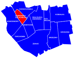
 Location of Dąbrówka Szlachecka within the district of Białołęka, in accordance to the Municipal Information System. | |
| Coordinates: 52°20′47.11″N 20°57′28.1″E / 52.3464194°N 20.957806°E | |
| Country | |
| Voivodeship | Masovian Voivodeship |
| City county | Warsaw |
| District | Białołęka |
| Time zone | UTC+1 (CET) |
| • Summer (DST) | UTC+2 (CEST) |
| Area code | +48 22 |
Dąbrówka Szlachecka is a neighbourhood, and an area of the Municipal Information System, in the city of Warsaw, Poland, located within the district of Białołęka.[1][2]
History[edit]
Dąbrówka Szlachecka was founded in 13th century, as a landed property of the local nobility, and between 16th century, it was a folwark-type settlement belonging to nearby Tarchomin.[3]
In 20th century, Dąbrówka Szlachecka used to be a small village near the city of Warsaw. On 15 May 1951, it had been incorporated into Warsaw.[4]
References[edit]
- ^ "Obszary MSI. Dzielnica Białołęka". zdm.waw.pl (in Polish).
- ^ "Osiedla Dąbrówka Szlachecka". bialoleka.um.warszawa.pl (in Polish).
- ^ Andrzej Sołtan (26 November 2014). "Od czasów najdawniejszych po wiek XVIII". bialoleka.um.warszawa.pl (in Polish).
- ^ Rozporządzenie Rady Ministrów z dnia 5 maja 1951 r. w sprawie zmiany granic miasta stołecznego Warszawy. In: 1951 Journal of Laws, no. 27, position 199. Warsaw. 1951.
