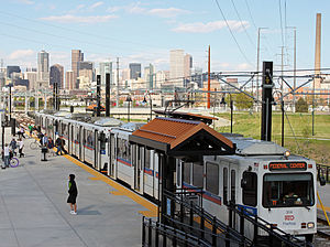
Decatur–Federal station
Appearance
Decatur - Federal Station | |||||||||||
|---|---|---|---|---|---|---|---|---|---|---|---|
| RTD light rail station | |||||||||||
 The station in May, 2013. | |||||||||||
| General information | |||||||||||
| Location | 1310 N. Federal Boulevard, Denver USA | ||||||||||
| Coordinates | 39°44′14″N 105°01′27″W / 39.73729°N 105.02403°W | ||||||||||
| Owned by | Regional Transportation District | ||||||||||
| Line(s) | |||||||||||
| Platforms | 2 side platforms | ||||||||||
| Tracks | 2 | ||||||||||
| Connections | RTD buses | ||||||||||
| Construction | |||||||||||
| Structure type | At grade | ||||||||||
| Parking | 1900 | ||||||||||
| Bicycle facilities | 10 Racks, 20 Lockers | ||||||||||
| Accessible | Yes | ||||||||||
| Other information | |||||||||||
| Fare zone | A[1] | ||||||||||
| History | |||||||||||
| Opened | April 2013 | ||||||||||
| Passengers | |||||||||||
| 2014 | 1,989 (avg. weekday)[2] | ||||||||||
| Rank | 25 out of 44[2] | ||||||||||
| Services | |||||||||||
| |||||||||||
Decatur - Federal Station is an RTD light rail station in Denver, Colorado, United States.[1] The station is part of the new W Line which was built as part of the FasTracks expansion. It opened in April, 2013 and is operated by the Regional Transportation District.
Neighborhood
The station is located in Denver's Sun Valley neighborhood, near the point where Lakewood Gulch meets the South Platte River. It is one of two light rail stops that serve Sports Authority Field at Mile High, the home stadium of the Denver Broncos. The stop is adjacent to Rude Park.
References
