Dierre
Appearance
Dierre | |
|---|---|
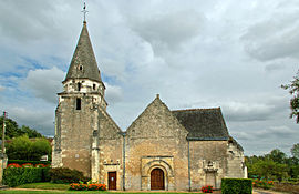
 The church of Saint Médard, in Dierre | |
| Country | France |
| Region | Centre-Val de Loire |
| Department | Indre-et-Loire |
| Arrondissement | Tours |
| Canton | Bléré |
| Government | |
| • Mayor (2008–2014) | Max Besnard |
Area 1 | 10.27 km2 (3.97 sq mi) |
| Population (2009) | 576 |
| • Density | 56/km2 (150/sq mi) |
| Time zone | UTC+01:00 (CET) |
| • Summer (DST) | UTC+02:00 (CEST) |
| INSEE/Postal code | 37096 /37150 |
| Elevation | 52–115 m (171–377 ft) |
| 1 French Land Register data, which excludes lakes, ponds, glaciers > 1 km2 (0.386 sq mi or 247 acres) and river estuaries. | |
Dierre is a commune in the Indre-et-Loire department in central France.
Population
The inhabitants are called Dierrois.
| Year | Pop. | ±% |
|---|---|---|
| 1793 | 491 | — |
| 1800 | 547 | +11.4% |
| 1806 | 571 | +4.4% |
| 1821 | 535 | −6.3% |
| 1831 | 571 | +6.7% |
| 1836 | 548 | −4.0% |
| 1841 | 529 | −3.5% |
| 1846 | 540 | +2.1% |
| 1851 | 565 | +4.6% |
| 1856 | 561 | −0.7% |
| 1861 | 565 | +0.7% |
| 1866 | 561 | −0.7% |
| 1872 | 560 | −0.2% |
| 1876 | 566 | +1.1% |
| 1881 | 535 | −5.5% |
| 1886 | 555 | +3.7% |
| 1891 | 528 | −4.9% |
| 1896 | 510 | −3.4% |
| 1901 | 493 | −3.3% |
| 1906 | 550 | +11.6% |
| 1911 | 506 | −8.0% |
| 1921 | 476 | −5.9% |
| 1926 | 455 | −4.4% |
| 1931 | 431 | −5.3% |
| 1936 | 424 | −1.6% |
| 1946 | 438 | +3.3% |
| 1954 | 425 | −3.0% |
| 1962 | 441 | +3.8% |
| 1968 | 426 | −3.4% |
| 1975 | 408 | −4.2% |
| 1982 | 416 | +2.0% |
| 1990 | 464 | +11.5% |
| 1999 | 496 | +6.9% |
| 2006 | 554 | +11.7% |
| 2009 | 576 | +4.0% |
See also
References
Wikimedia Commons has media related to Dierre.


