
Dobongsan
| Dobongsan | |
|---|---|
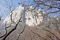
,_Manjangbong_(718m),_Jaunbong_(740m)_and_Shinseondae_(730m).JPG) Mount Dobongsan peaks Seoninbong (708 m), Manjangbong (718 m), Jaunbong (740 m) and Shinseondae (730 m) taken from trail leading to summit.
 Dobongsan Location | |
| Highest point | |
| Elevation | 739.5 m (2,426 ft) |
| Coordinates | 37°41′54.73″N 127°0′53.88″E / 37.6985361°N 127.0149667°E |
| Geography | |
| Location | South Korea |
| Climbing | |
| Easiest route | Dobongsan Station |
| Korean name | |
| Hangul | |
|---|---|
| Hanja | |
| Revised Romanization | Dobongsan |
| McCune–Reischauer | Tobongsan |
Dobongsan is a mountain in Bukhansan National Park, South Korea.[1] It extends across Seoul, the national capital, and the cities of Yangju and Uijeongbu, in the province of Gyeonggi-do.[2] It has an elevation of 739.5 m (2,426 ft).[3] Nearby Dobongsan Station is named after it.[4]
Gallery
-
 East face of Seoninbong Peak, Dobongsan taken from the trail leading to Manworam Temple.
 -
 Observation area on a peak of Dobongsan.
 -
 Rugged trail leading to peak of Dobongsan.
 -
 Wartime bunker on Dobongsan summit trail in Korea.
 -
 Petroglyph in stream bed at the foot of Dobongsan.
 -
 Temple on Dobongsan


See also
References
Wikimedia Commons has media related to Dobongsan.
- ^ "Dobongsan Mountain". Visit Korea. Korea Tourism Organization. Retrieved 2015-09-16.
- ^ "Bukhansan Dulle-gil Trail". Visit Korea. Korea Tourism Organization. Retrieved 2015-09-16.
- ^ Yu Jeong-yeol (2007). 한국의 산 여행 (Travel Guide to Korean Mountains). Seoul: 관동 상억연구회 (Kwandong). p. 47. ISBN 978-89-958055-1-0.
- ^ "도봉산역" (in Korean). KRIC. Retrieved 2015-09-16.