New Frankfurt Old Town


The Dom-Römer Project (German: Dom-Römer-Projekt) is an effort to make the old city center, the Altstadt (old town) of Frankfurt am Main, Germany, which was obliterated in the previous world war, look as if the war had never happened.
It aims to give the old town quarter between the Römerberg square and the Frankfurt Cathedral (Dom) a new life. The old city had already been thoroughly changed in 1904 by hewing several aisles for wide streets into the medieval cluster of insalubrious houslets and small alley ways, clearing the way for the tramway line thru the historic center.
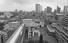
Due to the heavy bombing of Frankfurt am Main in World War II with many timber-framed buildings, most of the city's old town was razed to the ground. The efforts to rebuild parts of it began in the 1950s with the Römer city hall, which was built as a modern office building behind the old façade still standing after the war, and parts of the surrounding Römerberg square, building an underground multi-storey car park, and on top of that the modern Technisches Rathaus[1] (Technical City Hall, built 1972–74), whose façade made a reverence to the truss design (Fachwerk) of the pre-war architecture, but was also accused of being an example of a "Brutalist architecture". The Historisches Museum (Museum of city history) was also built, including a cinema In its entry area, this museum displayed a model of the old center as it looked at the end of World War II as a camp of ruins.
A change of direction came in the 1980ies when the Ostzeile (Eastern row) or Samstagsberg (Saturday hill), i.e. the line of houses opposite the Römer city hall, was built in a look old style, but with a problematic combination of both concrete and wood in the same construction.
This retrograde movement was later continued in a public campaign to demolish the Technische Rathaus and to make the old city look like beforte the war. This did finally succeed, the Technisches Rathaus and the Museum of City History were demolished in 2010/2011, and the construction of the backward movement could being.
In total, 35 buildings are projected until 2016, with 15 reconstructions of former old town buildings among them.[2]
This project, "return into the past", is being built on top of a 1970s underground multi-storey car park with an underground railway line underneath. Because of the destruction of the Technisches Rathaus, the underground moved and the tunnel had to be watched closely and corrected several times.
References
- ^ Photos of the former Technisches Rathaus Frankfurt
- ^ FAZ - Bedeutsame Altstadt-Häuser werden „qualitätvoll“ rekonstruiert (German)
Further reading
- Dietrich-Wilhelm Dreysse, Volkmar Hepp, Björn Wissenbach, Peter Bierling: Planung Bereich Dom - Römer. Dokumentation Altstadt. Stadtplanungsamt der Stadt Frankfurt am Main, Frankfurt am Main 2006 (online). (German)
- Stadtplanungsamt Frankfurt am Main: Im Dialog 1 - Städtebauliche und architektonische Neuordnung zwischen Dom und Römer. Beiträge zum Expertenhearing am 18. November 2005, Frankfurt am Main 2006 (German)
- Deutscher Werkbund Hessen e.V.: Standpunkte - Zur Bebauung des Frankfurter Römerbergs, Frankfurt am Main 2007 (German)
- Dietrich-Wilhelm Dreysse, Björn Wissenbach: Planung Bereich - Dom Römer. Spolien der Altstadt 1. Dokumentation der im Historischen Museum lagernden Originalbauteile Frankfurter Bürgerhäuser. Stadtplanungsamt, Frankfurt am Main 2008 (online). (German)
- Bundesministerium für Verkehr, Bau und Stadtentwicklung: Identität durch Rekonstruktion? Positionen zum Wiederaufbau verlorener Bauten und Räume. Dokumentation der Baukulturwerkstatt vom 16. Oktober 2008 in Berlin, Berlin 2009 (German)
External links
![]() Media related to Dom-Roemer-Projekt at Wikimedia Commons
Media related to Dom-Roemer-Projekt at Wikimedia Commons
- Official Dom-Römer website (German)
- Data sheets and drafts of reconstruction projects (German)
