Domburg, Suriname
Appearance
Domburg, Suriname | |
|---|---|
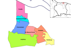
 Map showing the resorts of Wanica District. | |
| Country | |
| District | Wanica District |
| Area | |
| • Total | 37 km2 (14 sq mi) |
| Elevation | 5 m (16 ft) |
| Population (2012) | |
| • Total | 5,661 |
| • Density | 150/km2 (400/sq mi) |
| Time zone | UTC-3 (AST) |
Domburg is a resort in Suriname, located in the Wanica District. Its population at the 2012 census was 5,661.[1]
Domburg is located on the Suriname River, about 16 kilometers to the south of the capital of Paramaribo. It is bordered by the district Commewijne to the north and east, Para to the south and the resort Houttuin to the west. Near Domburg, an artificial white sand beach, White Beach, has been created along the Suriname River.

