Dominica Passage
Appearance
15°45′N 61°30′W / 15.75°N 61.5°W
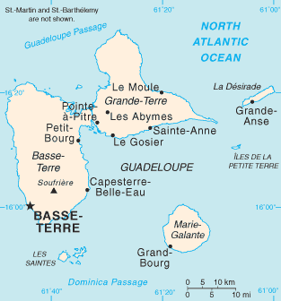
Dominica Passage is a strait in the Caribbean. It separates the islands of Dominica, from Îles des Saintes and Marie-Galante (Dependencies of Guadeloupe).


This is an old revision of this page, as edited by Hmains (talk | contribs) at 05:18, 14 April 2015 (copyedit, already indirectly in category, refine cat, and AWB general fixes using AWB). The present address (URL) is a permanent link to this revision, which may differ significantly from the current revision.
This article does not cite any sources. Please help improve this article by adding citations to reliable sources. Unsourced material may be challenged and removed. Find sources: "Dominica Passage" – news · newspapers · books · scholar · JSTOR (December 2009) (Learn how and when to remove this message) |
15°45′N 61°30′W / 15.75°N 61.5°W / 15.75; -61.5
Dominica Passage is a strait in the Caribbean. It separates the islands of Dominica, from Îles des Saintes and Marie-Galante (Dependencies of Guadeloupe).


This Guadeloupe location article is a stub. You can help Wikipedia by expanding it. |