
Domleschg
Domleschg | |
|---|---|
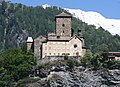
 Paspels village in Domleschg | |
Location of Domleschg  | |
| Country | Switzerland |
| Canton | Graubünden |
| District | Hinterrhein |
| Government | |
| • Mayor | Gemeindepräsident Werner Natter |
| Area | |
| • Total | 45.94 km2 (17.74 sq mi) |
| Elevation | 687 m (2,254 ft) |
| Population (31 December 2018)[2] | |
| • Total | 2,063 |
| • Density | 45/km2 (120/sq mi) |
| Time zone | UTC+01:00 (Central European Time) |
| • Summer (DST) | UTC+02:00 (Central European Summer Time) |
| Postal code(s) | 7415-7418 |
| SFOS number | 3673 |
| ISO 3166 code | CH-GR |
| Surrounded by | Cazis, Fürstenau |
| Website | www SFSO statistics |
Domleschg is a municipality in the district of Hinterrhein in the Swiss canton of Graubünden. On 1 January 2015 the former municipalities of Almens, Paspels, Pratval, Rodels and Tomils merged to form the new municipality of Domleschg.[3]
History
Almens is first mentioned in the first half of the 9th Century as de Lemenne.[4] Paspels is first mentioned in 1237 as in villa Pascuals though the original record no longer exists. In 1246 it was mentioned as de Pascuals.[5] Pratval is first mentioned in 1345 as Prau de Valle.[6] Rodels is first mentioned in the mid-12th Century as ad Rautine.[7] Tomils was created on 1 January 2009 through the merger of Feldis/Veulden, Scheid, Trans and Tumegl/Tomils.[8]
Geography
Based on the 2009 survery, the former municipalities that make up Domleschg had an area of 45.94 km2 (17.74 sq mi).[9] Of this area, 16.59 km2 (6.41 sq mi) or 36.1% was used for agricultural purposes, while 22.66 km2 (8.75 sq mi) or 49.3% was forested. Of the rest of the land, 1.5 km2 (0.58 sq mi) or 3.3% was settled (buildings or roads), 0.33 km2 (0.13 sq mi) or 0.7% was either rivers or lakes and 4.88 km2 (1.88 sq mi) or 10.6% was unproductive land.[10]
Of the built up area, housing and buildings made up 1.6% and transportation infrastructure made up 1.5%. Out of the forested land, 42.5% of the total land area is heavily forested and 4.9% is covered with orchards or small clusters of trees. Of the agricultural land, 5.1% is used for growing crops and 9.6% is pastures and 20.7% is used for alpine pastures. All the water in the municipality is flowing water. Of the unproductive areas, 8.9% is unproductive vegetation and 1.7% is too rocky for vegetation.[10]
Demographics
The total population of Domleschg (as of December 2020[update]) is 2,160.[11]
Historic population
The historical population is given in the following chart:[12]

Heritage sites of national significance
The Church of S. Luregn/St. Lorenz in Paspels, the Chapel of S. Maria-Magdalena in the hamlet of Dusch, Rietberg Castle in Pratval, the church of St. Maria E Maurezzi, the early medieval church of St. Murezzi and Ortenstein Castle in Tomils are listed as Swiss heritage sites of national significance. The regions around Paspels and Tumegl /Tomils-Ortenstein as well as the village of Almens are all part of the Inventory of Swiss Heritage Sites.[13]
The early medieval Church of S. Luregn/St. Lorenz was first mentioned in 1237. It was the parish church for the right side of the Hinterrhein valley. The Chapel of S. Maria-Magdalena was built in 1508 and was initially under the monastery of Churwalden. However, in the 16th Century, the hamlet of Dusch converted to the Reformation and therefore the chapel was also converted.[5]
-
 Chapel of St. Lorenz
 -
 Chapel of St. Maria-Magdalena
 -

-
 Interior of the Catholic Church of St. Maria E Maurezzi
 -
-
 Early medieval church of St. Murezzi


References
- ^ a b "Arealstatistik Standard - Gemeinden nach 4 Hauptbereichen". Federal Statistical Office. Retrieved 13 January 2019.
- ^ "Ständige Wohnbevölkerung nach Staatsangehörigkeitskategorie Geschlecht und Gemeinde; Provisorische Jahresergebnisse; 2018". Federal Statistical Office. 9 April 2019. Retrieved 11 April 2019.
- ^ Amtliches Gemeindeverzeichnis der Schweiz published by the Swiss Federal Statistical Office Template:De icon accessed 2 January 2013
- ^ Almens in German, French and Italian in the online Historical Dictionary of Switzerland.
- ^ a b Paspels in German, French and Italian in the online Historical Dictionary of Switzerland.
- ^ Pratval in German, French and Italian in the online Historical Dictionary of Switzerland.
- ^ Rodels in German, French and Italian in the online Historical Dictionary of Switzerland.
- ^ Tomils in German, French and Italian in the online Historical Dictionary of Switzerland.
- ^ Arealstatistik Standard - Gemeindedaten nach 4 Hauptbereichen
- ^ a b Swiss Federal Statistical Office-Land Use Statistics 2009 data Template:De icon accessed 15 January 2015
- ^ "Ständige und nichtständige Wohnbevölkerung nach institutionellen Gliederungen, Geburtsort und Staatsangehörigkeit". bfs.admin.ch (in German). Swiss Federal Statistical Office - STAT-TAB. 31 December 2020. Retrieved 21 September 2021.
- ^ Federal Statistical Office STAT-TAB Bevölkerungsentwicklung nach Region, 1850-2000 Template:De icon accessed 29 January 2011
- ^ Swiss inventory of cultural property of national and regional significance 21.11.2008 version, Template:De icon accessed 05-Oct-2009