
Dotson, Minnesota
Dotson, Minnesota | |
|---|---|
 Dotson, Minnesota  Dotson, Minnesota | |
| Coordinates: 44°10′19″N 94°59′41″W / 44.17194°N 94.99472°W | |
| Country | United States |
| State | Minnesota |
| County | Brown |
| Elevation | 1,083 ft (330 m) |
| Time zone | UTC-6 (Central (CST)) |
| • Summer (DST) | UTC-5 (CDT) |
| Area code | 507 |
| GNIS feature ID | 654676[1] |
Dotson is an unincorporated community in Brown County, in the U.S. state of Minnesota.[1]
History
Dotson was originally called Bedford, and under the latter name was laid out in 1899.[2] The present name is for Enoch Dotson, a local settler.[3] A post office called Dotson operated from 1901 until 1905.[4]
References
- ^ a b U.S. Geological Survey Geographic Names Information System: Dotson, Minnesota
- ^ Chicago and North Western Railway Company (1908). A History of the Origin of the Place Names Connected with the Chicago & North Western and Chicago, St. Paul, Minneapolis & Omaha Railways. p. 65.
- ^ Upham, Warren (1920). Minnesota Geographic Names: Their Origin and Historic Significance. Minnesota Historical Society. p. 69.
- ^ "Brown County". Jim Forte Postal History. Retrieved 16 March 2015.
Municipalities and communities of Brown County, Minnesota, United States | ||
|---|---|---|
| Cities | 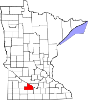 | |
| Townships | ||
| CDPs | ||
| Unincorporated communities | ||
| Footnotes | ‡This populated place also has portions in an adjacent county or counties | |