Dowreh County
Dowreh County
شهرستان دوره Chegeni County | |
|---|---|
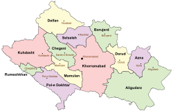
 Counties of Lorestan Province | |
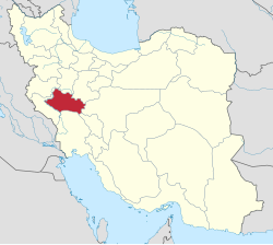
 Location of Lorestan Province in Iran | |
| Country | |
| Province | Lorestan Province |
| Capital | Sarab-e Dowreh |
| Bakhsh (Districts) | |
| Population (2006) | |
| • Total | 44,146 |
| Time zone | UTC+3:30 (IRST) |
| • Summer (DST) | UTC+4:30 (IRDT) |
Dowreh County (Do Râh Template:Lang-fa, and Chegeni County Template:Lang-fa[1]), is a county in Lorestan Province in Iran. The capital of the county is Sarab-e Dowreh. It was separated from Khorramabad County in 2007. At the 2006 census, the county's population was 44,146, in 9,722 families.[2] The county has two cities: Sarab-e Dowreh and Veysian.
Administrative divisions
The county is subdivided into three districts (bakhsh): Chegeni District (Central District), Shahivand District, and Veysian District, and further subdivided into six rural districts (dehestans): Dowreh, Teshkan, North Kashkan, South Kashkan, Shurab and Veysian.[1] There are 193 villages in the county.[1] Kashkan Rural District was divided into North Kashkan and South Kashkan in December 2007.[3]
References
- ^ a b c "تاريخچه شهرستان - موقعيت جغرافيايي شهرستان چگني:" [History of city - Geographical location Chegeni County:] (in Persian). Lorestan province. Archived from the original on 29 September 2015.
{{cite web}}: Unknown parameter|deadurl=ignored (|url-status=suggested) (help) - ^ "Census of the Islamic Republic of Iran, 1385 (2006)" (Excel). Statistical Center of Iran. Archived from the original on 2011-09-20.
- ^ "تصویب نامه درخصوص اصلاحات تقسیمات كشوری در استان لرستان - وزارت کشور" [Approved amendment to the divisions in the province - Ministry of Interior]. Laws and Regulations Portal of the Islamic Republic of Iran. 23 December 2007. Archived from the original on 29 September 2015.
{{cite web}}: Unknown parameter|deadurl=ignored (|url-status=suggested) (help)
- اطلس گیتاشناسی استانهای ایران [Atlas Gitashenasi Ostanhai Iran] (Gitashenasi Province Atlas of Iran)

