Draft:Ramsberg am Brombachsee
 | Review waiting, please be patient.
This may take 3 months or more, since drafts are reviewed in no specific order. There are 2,447 pending submissions waiting for review.
Where to get help
How to improve a draft
You can also browse Wikipedia:Featured articles and Wikipedia:Good articles to find examples of Wikipedia's best writing on topics similar to your proposed article. Improving your odds of a speedy review To improve your odds of a faster review, tag your draft with relevant WikiProject tags using the button below. This will let reviewers know a new draft has been submitted in their area of interest. For instance, if you wrote about a female astronomer, you would want to add the Biography, Astronomy, and Women scientists tags. Editor resources
Reviewer tools
|
| Submission declined on 31 January 2024 by DoubleGrazing (talk). This draft's references do not show that the subject qualifies for a Wikipedia article. In summary, the draft needs multiple published sources that are:
Where to get help
How to improve a draft
You can also browse Wikipedia:Featured articles and Wikipedia:Good articles to find examples of Wikipedia's best writing on topics similar to your proposed article. Improving your odds of a speedy review To improve your odds of a faster review, tag your draft with relevant WikiProject tags using the button below. This will let reviewers know a new draft has been submitted in their area of interest. For instance, if you wrote about a female astronomer, you would want to add the Biography, Astronomy, and Women scientists tags. Editor resources
This draft has been resubmitted and is currently awaiting re-review. |  |
 Comment: No indication of notability per WP:NPLACE, and the sources are insufficient to satisfy WP:GNG. DoubleGrazing (talk) 16:50, 31 January 2024 (UTC)
Ramsberg am Brombachsee | |
|---|---|
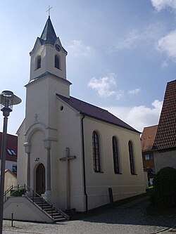
 Roman Catholic St. Joseph's Church in Ramsberg | |
| Coordinates: 49°07′06″N 10°55′56″E / 49.11833°N 10.93222°E | |
| Country | Germany |
| State | Bavaria |
| Admin. region | Mittelfranken |
| District | Weißenburg-Gunzenhausen |
| Municipality | Pleinfeld |
| Elevation | 423 m (1,388 ft) |
| Population | |
| • Total | 824[1] |
| Time zone | UTC+01:00 (CET) |
| • Summer (DST) | UTC+02:00 (CEST) |
| Postal codes | 91785 |
| Dialling codes | 09144 |

Ramsberg am Brombachsee is a district of the market town of Pleinfeld in the Weißenburg-Gunzenhausen district in the German state of Bavaria. The village has about 800 inhabitants.
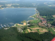
Ramsberg is located on the southern shore of the Großer Brombachsee, a lake in the Franconian Lake District. The surrounding area is characterized by rolling hills, forests, and agricultural land. The economy of Ramsberg is primarily driven by tourism.
Ramsberg has a railway station at the Nuremberg–Augsburg railway, which is served every 60 minutes on weekdays.[2]
The origins of the village date back to medieval times as Ramsberg was first mentioned in 1294. During the Thirty Years' War the population decreased very sharply. Ramsberg becomes part of Bavaria in 1803 by the process of mediatisation. The train station was opened in 1888. Ramsberg was an independent municipality until 1978 as Ramsberg got a district of Pleinfeld.[3]
References[edit]
- ^ Daten aus dem Bürgerbüro (pdf). In BürgerInfo. February 2024, p. 11.
- ^ "Ramsberg station". www.bahnhof.de.
- ^ "Ramsberg am Brombachsee - Markt Pleinfeld". www.pleinfeld.de.
External links[edit]
 Media related to Ramsberg am Brombachsee at Wikimedia Commons


