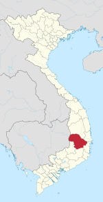
Ea H'leo district
This article relies largely or entirely on a single source. (September 2022) |
You can help expand this article with text translated from the corresponding article in Vietnamese. (March 2009) Click [show] for important translation instructions.
|
Eă H'léo district
Huyện Ea H'leo | |
|---|---|
 View of the road in Eă'Drăng township | |
 | |
| Coordinates: 13°14′N 108°12′W / 13.24°N 108.20°W | |
| Country | |
| Region | Central Highlands |
| Province | Đắk Lắk province |
| Capital | Eă'Drăng |
| Government | |
| • Type | District People's Committee |
| Area | |
• Total | 514 sq mi (1,331 km2) |
| Population (2018) | |
• Total | 128,347 |
| Time zone | UTC+7 (Indochina Time) |
Eă H'léo (Vietnamese: Ea H'leo) is a rural district of Đắk Lắk province in the Central Highlands of Vietnam.
History
[edit]Its name Eă H'léo means "the stream of the pepper trees" in Jarai language.
Eă H'léo is between Gia Lai province and Buôn Hồ rural district flowing Highway 14. Eă H'léo has great soil fertility, huge forests and other different resources, such as rubber and pepper. The main income of the population is coffee.
Geography
[edit]As of 2003, the district had a population of 106,185.[1] The district covers an area of 1,331 km2.
The capital of Eă H'léo rural district is Eă'Drăng township[1] ("the stream of the wings").
Besides, there are 11 communes : Cư A Mưng, Eă H'léo, Eă Tir, Eă Nlăm, Eă Khăl, Eă Răl, Eă Sòll, Cư Mớt, Eă H'láo, Dliê Yàng, Eă Wy.
Divisions
[edit]Besides the capital Ea'Đrăng, Ea H'leo has 11 villages:
- Cư A Mung
- Ea H'leo
- Ea Tir
- Ea Nam
- Ea Khăl
- Ea Ral
- Ea Sol
- Cư Mốt
- Ea Hiao
- Dliê Yang
- Ea Wy
See also
[edit]Notes and references
[edit]- ^ a b "Districts of Vietnam". Statoids. Retrieved March 13, 2009.


