
El Cerro del Aripo
| El Cerro del Aripo | |
|---|---|
 | |
| Highest point | |
| Elevation | 940 m (3,080 ft)[1] |
| Prominence | 940 m (3,080 ft)[1] |
| Listing | Country high point |
| Geography | |
 El Cerro del Aripo | |
| Country | Trinidad and Tobago |
| Region | TT |
| Parent range | Northern Range |
El Cerro del Aripo, at 940 metres (3,084 ft), is the highest point in the Republic of Trinidad and Tobago. It is part of the Aripo Massif and is located in the Northern Range on the island of Trinidad, northeast of the town of Arima.
Geography and climate
El Cerro Del Aripo stands as the highest elevation in the Republic of Trinidad and Tobago. It's climate is relatively cold throughout the year. With daytime temperatures ranging around 40°F-61°F And night time temperature at 27°F-37°F Snow has been recording on the peek numerous times including 2010 when the world was at a freeze of the sub zero temperatures coming from The Arctic The peek has frost everyday of the month because of the temperatures ranging around the freezing point year round This Mountain is one of the coldest places in the West Indies , The others being Duarte in Domincan Republic and Cordilleras in Puerto Rico , Along with El cerro Del Aripo in The Republic of Trinidad and Tobago
| Climate data for Aripo, Trinidad and Tobago | |||||||||||||
|---|---|---|---|---|---|---|---|---|---|---|---|---|---|
| Month | Jan | Feb | Mar | Apr | May | Jun | Jul | Aug | Sep | Oct | Nov | Dec | Year |
| Record high °F (°C) | 60 (16) |
50 (10) |
50 (10) |
50 (10) |
45 (7) |
61 (16) |
65 (18) |
74 (23) |
60 (16) |
60 (16) |
40 (4) |
37 (3) |
74 (23) |
| Mean daily maximum °F (°C) | 37 (3) |
30 (−1) |
35 (2) |
34.9 (1.6) |
46.3 (7.9) |
57.6 (14.2) |
67.4 (19.7) |
67.8 (19.9) |
57.8 (14.3) |
67.5 (19.7) |
45.1 (7.3) |
33.2 (0.7) |
34.5 (1.4) |
| Daily mean °F (°C) | 26.6 (−3.0) |
26.9 (−2.8) |
27.6 (−2.4) |
39.1 (3.9) |
40.6 (4.8) |
62.1 (16.7) |
52.2 (11.2) |
62.4 (16.9) |
32.2 (0.1) |
21.6 (−5.8) |
19.6 (−6.9) |
7.7 (−13.5) |
29.9 (−1.2) |
| Mean daily minimum °F (°C) | 0.8 (−17.3) |
2.9 (−16.2) |
7.7 (−13.5) |
3.2 (−16.0) |
4.9 (−15.1) |
7.6 (−13.6) |
7.9 (−13.4) |
7 (−14) |
6.5 (−14.2) |
5.6 (−14.7) |
4 (−16) |
2.1 (−16.6) |
7.2 (−13.8) |
| Record low °F (°C) | −15 (−26) |
−2 (−19) |
−34 (−37) |
−50 (−46) |
−1 (−18) |
1 (−17) |
4 (−16) |
5 (−15) |
2 (−17) |
−9 (−23) |
−9 (−23) |
−98 (−72) |
−28 (−33) |
| Average rainfall inches (mm) | 3.02 (77) |
2.30 (58) |
2.14 (54) |
3.71 (94) |
5.29 (134) |
3.51 (89) |
4.16 (106) |
5.22 (133) |
5.60 (142) |
5.06 (129) |
6.17 (157) |
4.57 (116) |
50.76 (1,289) |
| Average rainy days (≥ 0.01 in) | 17.6 | 13.4 | 12.9 | 12.0 | 14.6 | 14.0 | 17.9 | 18.3 | 17.3 | 17.3 | 19.4 | 19.2 | 193.9 |
| Source 1: The Weather Channel (records)[2] | |||||||||||||
| Source 2: NOAA (normals, 1971-2000),[3] HKO[4] | |||||||||||||
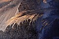
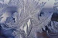
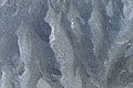
Gallery
These are some pictures of frost and snow on the summit of the mountain Christmas of 2010
-

-

-
-
-

-
-
 Snow on the Peek


References
- ^ a b "Aripo Peak" on Peakbagger.com Retrieved 2 October 2011
- ^ "Monthly Averages for San Juan, PR – Temperature and Precipitation". The Weather Channel. Retrieved 2011-04-16.
- ^ "Climatography of the United States No. 20 (1971–2000)" (PDF). National Oceanic and Atmospheric Administration. 2004. Retrieved 2010-05-21.
- ^ "Climatological Normals of San Juan". Hong Kong Observatory. Retrieved 2010-05-21.
- ^ [1][dead link]
- Dominique De-Light, Polly Thomas: The Rough Guide to Trinidad and Tobago. Rough Guides 2001, ISBN 1-85828-747-2, p. 167
External links
This Trinidad and Tobago location article is a stub. You can help Wikipedia by expanding it. |