Eurasian Basin

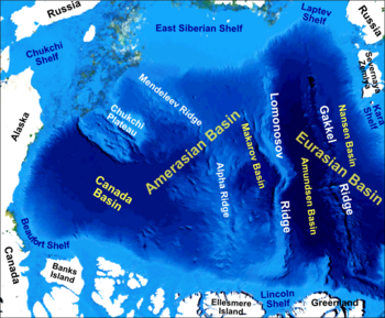
The Eurasian Basin, is one of the two major basins into which the North Polar Basin of the Arctic Ocean is split by the Lomonosov Ridge, the other big basin is the Amerasian Basin. The Eurasian Basin may be seen as an extension of the North Atlantic Basin through Fram Strait. It is further split by the Nansen-Gakkel Ridge into the Nansen Basin and the Amundsen Basin. The latter basin is the deepest one of the Arctic Ocean and the geographic North Pole located there.
The Eurasian Basin is bounded from the South by Greenland and the Svalbard archipelago, the Lomonosov Ridge, and the Siberian shelves of Laptev Sea, Kara Sea and Barents Sea. The maximum depth is reached at the Litke Deep with 5449 m depth.[1]
It is believed to be of Cenozoic origin: it was created about 63 m.y. ago by the spreading of the sea floor.[2]
References
- ^ Physical characteristics of the Arctic
- ^ "Plate Tectonics Model for the Evolution of the Arctic", Geology, vol. 2, Issue 8, p.377 (1974) doi:10.1130%2F0091-7613%281974%292%3C377%3APTMFTE%3E2.0.CO%3B2
