Europa (Roman province)
This article needs additional citations for verification. (September 2014) |
| Province of Europa Provincia Europae | |
|---|---|
| Province of the Roman Empire | |
| 314 – 640s | |
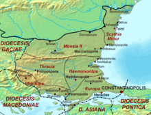
 Europa within the Diocese of Thrace c. 400. | |
| Capital | Perinthus |
| Historical era | Late Antiquity |
• Reforms of Diocletian | 314 |
• Thematic reforms | 640s |
| Today part of | |
Europa was a Roman province within the Diocese of Thrace.
History
Established by Roman Emperor Diocletian in 314, the province largely corresponds to what is modern day European Turkey. The province's capital was Perinthus (later known as Heraclea; modern Marmara Ereğlisi).
Bordering only the provinces of Rhodope and Haemimontus to the west and northwest, Europa was a peninsula and was surrounded by water on three sides: the Black Sea to the northeast, the Bosphorus to the east, and the Sea of Marmara and Aegean Sea to the south and southeast.
The largest city along the Black Sea was Salmydessus. Along the coast of the Sea of Marmara were the cities of Perinthus (the capital; later known as Heraclea), Selymbria, Raidestus, and Callipolis. On the coast of the Aegean and at the mouth of the Hebrus river in the Melas Gulf was the city of Aenus (Thrace).
Episcopal sees
Ancient episcopal sees of the Roman province of Europa listed in the Annuario Pontificio as titular sees:[1]
- Aprus (Apros)
- Arcadiopolis in Europa
- Athyra
- Bizya (Vize)
- Callipolis (Gelibolu)
- Chalcis in Europa (İnecik, Tekirdağ)
- Chariopolis
- Chersonesus in Europa (near Hexamili)
- Coela (Kilya)
- Daonia (Eski Eregli)
- Dercos
- Garella (Karayli?)
- Heraclea in Europa (Marmara Ereğlisi)
- Hexamilium ?Lysimachia (Thrace)
- Lizicus
- Madytus
- Metrae (Çatalca, in Istanbul)
- Pamphilus (Pavlo-Köy)
- Panium (Rumelifeneri, Sarıyer)
- Perinthus (Marmara Ereğlisi), the Metropolitan Archbishopric
- Peristasis (Sarköy)
- Rhaedestus
- Sabadia (Urce near Kavak?)
- Selymbria
- Sergentza (Binkılıç)
- Theodoropolis (Badoma?)
- Zorolus (Çorlu)
References
- ^ Annuario Pontificio 2013 (Libreria Editrice Vaticana 2013 ISBN 978-88-209-9070-1), "Sedi titolari", pp. 819-1013
