
Everettville, West Virginia
Everettville, West Virginia | |
|---|---|
 Everettville, West Virginia  Everettville, West Virginia | |
| Coordinates: 39°33′49″N 80°03′47″W / 39.56361°N 80.06306°W | |
| Country | United States |
| State | West Virginia |
| County | Monongalia |
| Elevation | 896 ft (273 m) |
| Time zone | UTC-5 (Eastern (EST)) |
| • Summer (DST) | UTC-4 (EDT) |
| Area code(s) | 304 & 681 |
| GNIS feature ID | 1554421[1] |
Everettville is an unincorporated community in Monongalia County, West Virginia, United States. Everettville is located along County Route 45 and Little Indian Creek, 7.3 miles (11.7 km) southwest of Morgantown.[2] Everettville had a post office, which closed on November 2, 2002.[3]
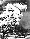
On April 30, 1927, an explosion at the Federal No. 3 Coal Mine in Everettville caused the death of approximately 111 coal miners, a disaster that ranks among the deadliest coal mine accidents in United States history.[4]
References
- ^ "Everettville". Geographic Names Information System. United States Geological Survey, United States Department of the Interior.
- ^ Monongalia County, West Virginia General Highway Map (PDF) (Map). West Virginia Department of Transportation. 2011. p. 2. Archived from the original (PDF) on 2012-04-25. Retrieved March 7, 2012.
{{cite map}}: Unknown parameter|deadurl=ignored (|url-status=suggested) (help) - ^ "Postmaster Finder - Post Offices by ZIP Code". United States Postal Service. Retrieved March 7, 2012.
- ^ http://www.wveha.org/history/Disaster

Deadliest coal mine disasters in the United States | ||
|---|---|---|
|  | |
This article about a location in Monongalia County, West Virginia is a stub. You can help Wikipedia by expanding it. |