
Evergem
Evergem | |
|---|---|
 Sleidinge | |
 Flag  Coat of arms | |
Location of Evergem  | |
 Evergem Location in Belgium
Location of Evergem in East Flanders  | |
| Coordinates: 51°07′N 03°42′E / 51.117°N 3.700°E | |
| Country | |
| Community | Flemish Community |
| Region | Flemish Region |
| Province | East Flanders |
| Arrondissement | Ghent |
| Government | |
| • Mayor | Joeri De Maertelaere (N-VA) |
| • Governing party/ies | N-VA, CD&V |
| Area | |
| • Total | 75.37 km2 (29.10 sq mi) |
| Population (2018-01-01)[1] | |
| • Total | 35,239 |
| • Density | 470/km2 (1,200/sq mi) |
| Postal codes | 9940 |
| NIS code | 44019 |
| Area codes | 09 |
| Website | www.evergem.be |
Evergem (Dutch pronunciation: [ˈeːvərɣɛm]) is a municipality located in the Belgian province of East Flanders. The municipality comprises the towns of Belzele, Doornzele, Ertvelde, Evergem proper, Kerkbrugge-Langerbrugge, Kluizen, Rieme, Sleidinge and Wippelgem. On January 1, 2006, Evergem had a total population of 32,244. The total area is 75.04 square kilometres (28.97 sq mi) which gives a population density of 430 inhabitants per km².
Demographics

Opm:Bron:NIS
Famous inhabitants
- Angelus de Baets, portrait painter (1793- Ghent, 1855)
- Luc De Vos, singer of the band Gorki
- Wilfried Martens, former Belgian prime minister, former chairman of the European People's Party (1963 - 2013)
- Eddy Wally, singer
- Jun Song, Big Brother winner
International relations
Twin towns — Sister cities
Evergem is twinned with:
Gallery
-
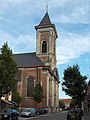 Evergem, church: de Sint Kristoffelkerk
 -
 Sleidinge, Dorp 4 tm 6
 -
 Wippelgem, windmill: de Gerardsmolen
 -
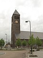
 Kluizen, church: de Onze Lieve Vrouw Geboortekerk
 -
 Ertvlede, church: parochiekerk Onze Lieve Vrouwe Hemelvaart
 -
 Ertvelde, windmill: de Stenenmolen


References
- ^ "Wettelijke Bevolking per gemeente op 1 januari 2018". Statbel. Retrieved 9 March 2019.
- ^ Błażejowski, Tomasz (4 June 2010). "Stalowa Wola podpisała porozumienie z Belgami" (in Polish). Stalowka.NET. Retrieved 2013-07-21.
External links
Wikimedia Commons has media related to Evergem.
Places adjacent to Evergem | |
|---|---|
| Aalst |  | |
|---|---|---|
| Dendermonde | ||
| Eeklo | ||
| Ghent | ||
| Oudenaarde | ||
| Sint-Niklaas | ||
| ||
| International | |
|---|---|
| National | |
| Geographic | |