
Ferndale, Washington
This article includes a list of references, related reading, or external links, but its sources remain unclear because it lacks inline citations. (September 2008) |
Ferndale, Washington | |
|---|---|
 Location of Ferndale, Washington | |
| Country | United States |
| State | Washington |
| County | Whatcom |
| Government | |
| • Mayor | Gary Jensen |
| Area | |
| • Total | 6.3 sq mi (16.2 km2) |
| • Land | 6.2 sq mi (16.1 km2) |
| • Water | 0.1 sq mi (0.1 km2) |
| Elevation | 36 ft (11 m) |
| Population | |
| • Total | 11,415 |
| • Density | 1,409.1/sq mi (544.1/km2) |
| Time zone | UTC-8 (Pacific (PST)) |
| • Summer (DST) | UTC-7 (PDT) |
| ZIP code | 98248 |
| Area code | 360 |
| FIPS code | 53-23620Template:GR |
| GNIS feature ID | 1512205Template:GR |
| Demonym | Ferndaler, Ferndalian[2] |
| Website | www.ci.ferndale.wa.us |
Ferndale is a city in Whatcom County, Washington, United States. The population was 11,415 at the 2010 census.[1]
History
First settled in 1872, Ferndale was given its name because of the ferns that once grew around the original school house.[3] Ferndale was originally called Jam because the town was located next to a log jam on the Nooksack River. The original schoolteacher decided it needed a more picturesque name. Ferndale was officially incorporated on March 19, 1907.
Geography
Ferndale is located at 48°50′48″N 122°35′23″W / 48.84667°N 122.58972°W (48.846670, -122.589720).Template:GR
The city has a total area of 6.3 square miles (16.2 km²), of which 6.2 square miles (16.1 km²) is land and 0.1 square miles (0.1 km²) (0.80%) is water.
Climate
| Climate data for Ferndale, Washington | |||||||||||||
|---|---|---|---|---|---|---|---|---|---|---|---|---|---|
| Month | Jan | Feb | Mar | Apr | May | Jun | Jul | Aug | Sep | Oct | Nov | Dec | Year |
| Mean daily maximum °F (°C) | 45 (7) |
49 (9) |
52 (11) |
57 (14) |
62 (17) |
66 (19) |
71 (22) |
72 (22) |
68 (20) |
59 (15) |
50 (10) |
45 (7) |
59.0 (15.0) |
| Mean daily minimum °F (°C) | 32 (0) |
35 (2) |
37 (3) |
41 (5) |
46 (8) |
51 (11) |
54 (12) |
54 (12) |
49 (9) |
42 (6) |
37 (3) |
33 (1) |
44.1 (6.7) |
| Average precipitation inches (mm) | 4.83 (123) |
3.56 (90) |
3.03 (77) |
2.75 (70) |
2.31 (59) |
1.95 (50) |
1.37 (35) |
1.25 (32) |
1.61 (41) |
3.25 (83) |
5.44 (138) |
4.90 (124) |
36.25 (922) |
| Source: The Weather Channel [4] | |||||||||||||
Demographics
As of the censusTemplate:GR of 2009, there were 11,681 people, 3,901 households, and 2,303 families residing in the city. The population density was 1,409.1 people per square mile (543.6/km²). There were 3,292 housing units at an average density of 529.7 per square mile (204.3/km²). The racial makeup of the city was 84.85% White, 0.82% African American, 2.56% Native American, 2.43% Asian, 0.25% Pacific Islander, 5.31% from other races, and 3.78% from two or more races. Hispanic or Latino of any race were 9.02% of the population.
There were 3,147 households, of which 42.2% had children under age 18, 55.3% were married couples living together, 13.3% had a female householder with no husband present, and 26.8% were non-families. 21.6% of all households were made up of individuals and 8.2% had someone living alone who was 65 years of age or older. The average household size was 2.77; the average family size was 3.25.
In the city the age distribution of the population shows 32.5% under the age of 18, 8.2% from 18 to 24, 30.4% from 25 to 44, 19.4% from 45 to 64, and 9.5% who were 65 years of age or older. The median age was 32 years. For every 100 females there were 95.6 males. For every 100 females age 18 and over, there were 92.4 males.
The median household income in the city was $36,375, and the median income for a family was $44,626. Males had a median income of $34,658 versus $25,851 for females. The per capita income for the city was $15,982. About 10.4% of families and 13.2% of the population were below the poverty line, including 19.0% of those under age 18 and 9.2% of those age 65 or over.
Local Culture
Events
- Downtown Trick or Treat in October[5]
- Community Wide Garage Sale (Always the First Saturday of May) [6]
- May 2011 Ferndale Business Expo[7]
- Chamber of Commerce 'Street Festival' & 'Music Festival' (Held the last weekend of August)
- Old Settlers Picnic and Grand Parade (last weekend in July every year) [8]
Other
- Ferndale is noted for its "Metallica Bridge." The Metallica logo has been a cult-like icon on the main railroad bridge for 26 years. Attempts have been made to paint over the stalwart, but none have lasted. The Metallica Bridge has a Facebook fan page with over 1200 fans, with a stated goal of bringing Metallica to Ferndale to play a free concert.
- The Whatcom Dead: The Whatcom Dead is an organization that revolves around the genere of Zombies (lead organizer B. Harris). This group of fans are supporters of the Arts regarding anything Zombie related. The group began as a Facebook club, but they now hold much higher ambitions from film making to parades of the dead.
Sister city
Ferndale has the following sister city relationship:
Gallery
-
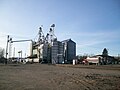 Grain storage and rail line.
 -
 Main street.
 -
 Metallica bridge over the Nooksack River.


Notable People From Ferndale
- Jake Locker - Quarterback for the Tennessee Titans
- Doug Pederson - Quarterbacks coach for the Philadelphia Eagles
- Michael Koenen - Current punter for the Tampa Bay Buccaneers
- Dennis Erickson - Head football coach at Arizona State
- Daran Norris - actor, most notably for voice work and a recurring role on the television series Veronica Mars
- Jesse Brand - Songwriter for Broadcast Music Incorporated and Nashville Recording Artist
See also
References
- ^ a b "Ferndale - Census 2010". Spokane Spokesman Review. Retrieved 2011-03-05.
- ^ Sam Taylor (April 28, 2008). "Ferndale Skatepark lightning rod volunteer also manning anti-school bond campaign". The Bellingham Herald. Retrieved 2008-10-18.
- ^ Majors, Harry M. (1975). Exploring Washington. Van Winkle Publishing Co. p. 20. ISBN 9780918664006.
- ^ "Average Weather for Ferndale, WA - Temperature and Precipitation". Retrieved 2010-12-22.
- ^ "Ferndale Chamber of Commerce".
- ^ "Ferndale Chamber of Commerce".
- ^ "Ferndale Business Expo".
- ^ "Whatcom County Old Settlers Association".
- ^ "Sister Relationships".
External links
- http://www.ferndale.net
- http://www.ci.ferndale.wa.us
- Ferndale Chamber of Commerce
- Ferndale School District
- Bellingham Whatcom County Tourism
- Whatcom County Library System, serving Ferndale and surrounding areas
Municipalities and communities of Whatcom County, Washington, United States | ||
|---|---|---|
| Cities |  | |
| CDPs | ||
| Indian reservations | ||
| Unincorporated communities | ||
| Ghost towns | ||