
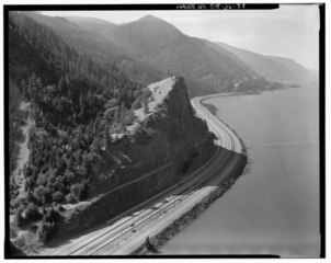
File:AERIAL VIEW OF MITCHELL POINT. HISTORIC COLUMBIA RIVER HIGHWAY ON SIDE OF CLIFF. - Historic Columbia River Highway, Troutdale, Multnomah County, OR HAER ORE,26-TROUT.V,1-79.tif

Size of this JPG preview of this TIF file: 753 × 599 pixels. Other resolutions: 302 × 240 pixels | 603 × 480 pixels | 965 × 768 pixels | 1,280 × 1,019 pixels | 2,560 × 2,037 pixels | 5,000 × 3,979 pixels.
Original file (5,000 × 3,979 pixels, file size: 18.98 MB, MIME type: image/tiff)
| This is a file from the Wikimedia Commons. Information from its description page there is shown below. Commons is a freely licensed media file repository. You can help. |
Summary
| AERIAL VIEW OF MITCHELL POINT. HISTORIC COLUMBIA RIVER HIGHWAY ON SIDE OF CLIFF. - Historic Columbia River Highway, Troutdale, Multnomah County, OR | ||||
|---|---|---|---|---|
| Photographer |
Related names:
|
|||
| Title |
AERIAL VIEW OF MITCHELL POINT. HISTORIC COLUMBIA RIVER HIGHWAY ON SIDE OF CLIFF. - Historic Columbia River Highway, Troutdale, Multnomah County, OR |
|||
| Depicted place | Oregon; Multnomah County; Troutdale | |||
| Date | Documentation compiled after 1968 | |||
| Dimensions | 4 x 5 in. | |||
| Current location |
Library of Congress Prints and Photographs Division Washington, D.C. 20540 USA http://hdl.loc.gov/loc.pnp/pp.print |
|||
| Accession number |
HAER ORE,26-TROUT.V,1-79 |
|||
| Credit line |
|
|||
| Notes |
|
|||
| References |
|
|||
| Source | https://www.loc.gov/pictures/item/or0386.photos.354730p | |||
| Permission (Reusing this file) |
|
|||

| Object location | | View this and other nearby images on: OpenStreetMap |
|---|
File history
Click on a date/time to view the file as it appeared at that time.
| Date/Time | Thumbnail | Dimensions | User | Comment | |
|---|---|---|---|---|---|
| current | 08:38, 2 August 2014 |  | 5,000 × 3,979 (18.98 MB) | Fæ | GWToolset: Creating mediafile for Fæ. HABS 2014-08-01 2601-2900 missing |
File usage
The following pages on the English Wikipedia use this file (pages on other projects are not listed):