
File:North elevation. Oblique view to southeast. - Passaic River Bridge, Spanning Passaic River on U.S. Route 46, Paterson, Passaic County, NJ HAER NJ,16-PAT,37-5.tif

Size of this JPG preview of this TIF file: 482 × 599 pixels. Other resolutions: 193 × 240 pixels | 386 × 480 pixels | 618 × 768 pixels | 824 × 1,024 pixels | 1,648 × 2,048 pixels | 4,024 × 5,000 pixels.
Original file (4,024 × 5,000 pixels, file size: 19.19 MB, MIME type: image/tiff)
| This is a file from the Wikimedia Commons. Information from its description page there is shown below. Commons is a freely licensed media file repository. You can help. |
Summary
| North elevation. Oblique view to southeast. - Passaic River Bridge, Spanning Passaic River on U.S. Route 46, Paterson, Passaic County, NJ | ||||
|---|---|---|---|---|
| Photographer |
Tucher, Rob, creator |
|||
| Title |
North elevation. Oblique view to southeast. - Passaic River Bridge, Spanning Passaic River on U.S. Route 46, Paterson, Passaic County, NJ |
|||
| Depicted place | New Jersey; Passaic County; Paterson | |||
| Date | 1993 | |||
| Dimensions | 4 x 5 in. | |||
| Current location |
Library of Congress Prints and Photographs Division Washington, D.C. 20540 USA http://hdl.loc.gov/loc.pnp/pp.print |
|||
| Accession number |
HAER NJ,16-PAT,37-5 |
|||
| Credit line |
|
|||
| Source | https://www.loc.gov/pictures/item/nj1529.photos.347494p | |||
| Permission (Reusing this file) |
|
|||

File history
Click on a date/time to view the file as it appeared at that time.
| Date/Time | Thumbnail | Dimensions | User | Comment | |
|---|---|---|---|---|---|
| current | 19:46, 28 July 2014 | 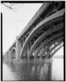 | 4,024 × 5,000 (19.19 MB) | Fæ | GWToolset: Creating mediafile for Fæ. HABS 24 July 2014 (2301:2600) |
File usage
The following pages on the English Wikipedia use this file (pages on other projects are not listed):