
File:Old Railway Bridge Across Kao-Ping River.jpg

Size of this preview: 800 × 600 pixels. Other resolutions: 320 × 240 pixels | 640 × 480 pixels | 1,024 × 768 pixels.
Original file (1,024 × 768 pixels, file size: 646 KB, MIME type: image/jpeg)
| This is a file from the Wikimedia Commons. Information from its description page there is shown below. Commons is a freely licensed media file repository. You can help. |
Summary
| Description |
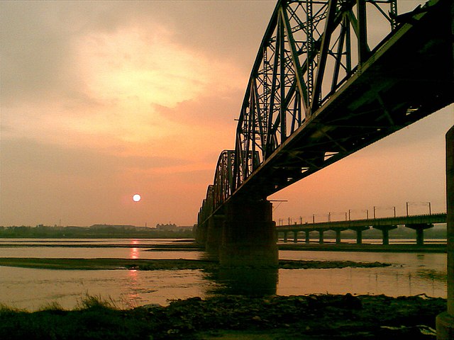
English: The Old Gaoping Bridge also called The Bridge of Siadanshui River,is a Warren Truss on the Pingtung Line in Taiwan.The photo shows sunset of the bridge. Русский: Старый железнодорожный мост в Тайване 中文(臺灣):舊高屏鐵橋又稱下淡水溪鐵橋,是位在臺灣屏東線一座華倫式桁架橋。這張圖顯示是舊高屏鐵橋的夕照。 中文(简体):旧高屏铁桥又称下淡水溪铁桥,是位在台湾屏东线一座华伦式桁架桥。这张图显示是旧高屏铁桥的夕照。 |
| Date | |
| Source | Own work |
| Author | Jessepylin |
| Other versions | Derivative works of this file: Kaohsiung montage 2010.jpg |
| Camera location | | View this and other nearby images on: OpenStreetMap |
|---|
Licensing
I, the copyright holder of this work, hereby publish it under the following licenses:
This file is licensed under the Creative Commons Attribution-Share Alike 3.0 Unported license.
- You are free:
- to share – to copy, distribute and transmit the work
- to remix – to adapt the work
- Under the following conditions:
- attribution – You must give appropriate credit, provide a link to the license, and indicate if changes were made. You may do so in any reasonable manner, but not in any way that suggests the licensor endorses you or your use.
- share alike – If you remix, transform, or build upon the material, you must distribute your contributions under the same or compatible license as the original.

|
Permission is granted to copy, distribute and/or modify this document under the terms of the GNU Free Documentation License, Version 1.2 or any later version published by the Free Software Foundation; with no Invariant Sections, no Front-Cover Texts, and no Back-Cover Texts. A copy of the license is included in the section entitled GNU Free Documentation License. |
You may select the license of your choice.
File history
Click on a date/time to view the file as it appeared at that time.
| Date/Time | Thumbnail | Dimensions | User | Comment | |
|---|---|---|---|---|---|
| current | 07:11, 10 March 2010 | | 1,024 × 768 (646 KB) | Jessepylin~commonswiki | {{Information |Description={{zh|1=黃昏日落時分的舊高屏鐵路橋}} |Source={{own}} |Author=Jessepylin |Date=Sept. 20, 2008 |Permission= |other_versions= }} Category:Railway Bridges in Taiwan |
File usage
The following pages on the English Wikipedia use this file (pages on other projects are not listed):
Global file usage
The following other wikis use this file:
- Usage on ceb.wikipedia.org
- Usage on de.wikipedia.org
- Usage on es.wikipedia.org
- Usage on fr.wikipedia.org
- Usage on hy.wikipedia.org
- Usage on it.wikipedia.org
- Usage on ja.wikipedia.org
- Usage on mn.wikipedia.org
- Usage on pl.wikipedia.org
- Usage on ru.wikipedia.org
- Usage on vi.wikipedia.org
- Usage on www.wikidata.org
- Usage on zh-min-nan.wikipedia.org
- Usage on zh.wikipedia.org